Sīlat az̧ Z̧ahr elevation
Sīlat az̧ Z̧ahr (West Bank, Jenin), Palestinian Territory elevation is 390 meters and Sīlat az̧ Z̧ahr elevation in feet is 1280 ft above sea level [src 1]. Sīlat az̧ Z̧ahr is a populated place (feature code) with elevation that is 77 meters (253 ft) smaller than average city elevation in Palestinian Territory.
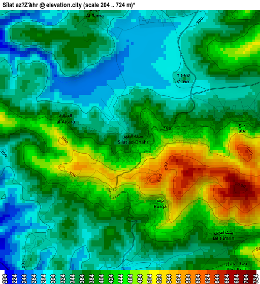
Below is the Elevation map of Sīlat az̧ Z̧ahr, which displays elevation range with different colors. Scale of the first map is from 204 to 724 m (669 to 2375 ft) with average elevation of 382.1 meters (=1254 ft) [note 1]
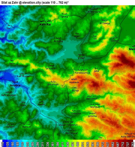
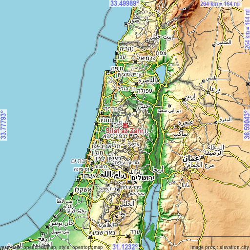
These maps also provides idea of topography and contour of this city, they are displayed at different zoom levels. More info about maps, scale and edge coordinates you can find below images.
| \ | Map #1 | Map #2 | Topo.Map |
| Scale [m] | 204..724 m | 110..762 m | × |
| Scale [ft] | 669..2375 ft | 361..2500 ft | × |
| Average | 382.1 m = 1254 ft | 384.9 m = 1263 ft | × |
| Width | 8.26 km = 5.1 mi | 16.52 km = 10.3 mi | 264.3 km = 164.2 mi |
| Height | 8.26 km = 5.1 mi | 16.52 km = 10.3 mi | 264.3 km = 164.2 mi |
| ↑Max Latitude | 32.35647° | 32.393584° | 33.49989° |
| Latitude at center | 32.31934° | 32.31934° | 32.31934° |
| ↓Min Latitude | 32.282195° | 32.245035° | 31.1232° |
| ← Min Longitude | 35.140235° | 35.096289° | 33.77793° |
| Longitude center | 35.18418° | 35.18418° | 35.18418° |
| →Max Longitude | 35.228125° | 35.272071° | 36.59043° |
Nearby cities:
Cities around Sīlat az̧ Z̧ahr sort by population:
• Jaba‘ elevation 419 m
3.5 km,  81°
81°
• ‘Anabtā 174 m
6.4 km,  258°
258°
• ‘Ajjah 422 m
4.7 km,  13°
13°
• Burqah 456 m
2.1 km,  157°
157°
• Al Fandaqūmīyah 455 m
1.8 km,  85°
85°
• Sabasţīyah 369 m
5 km, 164°
• Bayt Imrīn 442 m
4.2 km,  134°
134°
• Bazzāryah 478 m
2.1 km,  233°
233°
• Rāmīn 337 m
5 km,  220°
220°
• ‘Anzah 417 m
5.6 km,  37°
37°
• An Nāqūrah 445 m
6.2 km,  165°
165°
• Al ‘Aţţārah 360 m
2 km,  290°
290°
Multilingual:
 En español:
Sīlat az̧ Z̧ahr elevación 390 m.
 En France:
Sīlat az̧ Z̧ahr élévation 390 m.
 Auf Deutsch:
Sīlat az̧ Z̧ahr höhe über dem Meeresspiegel ist 390 m.

Sources and notes:
- [note 1] Map square and city borders are not equal. Map elevation data is calculated only from area inside that square.
- [src 1] Elevation data from geonames database provided with same terms of usage.
- [src 2] The elevation map of Sīlat az̧ Z̧ahr is generated using elevation data from NASA's 3 arcsec (90m) resolution SRTM data.
- [src 3] Base (background) map © OpenStreetMap contributors tiles are generated by Geofabrik and OpenTopoMap.
Copyright & License:
This Sīlat az̧ Z̧ahr Elevation Map is licensed under CC BY-SA. You may reuse any part from this page, if you give a proper credit by linking to this URL:
 More info on terms of use page.