Banī Zayd elevation
Banī Zayd, Palestinian Territory elevation is 480 meters and Banī Zayd elevation in feet is 1575 ft above sea level [src 1]. Banī Zayd is a populated place (feature code) with elevation that is 13 meters (43 ft) bigger than average city elevation in Palestinian Territory.
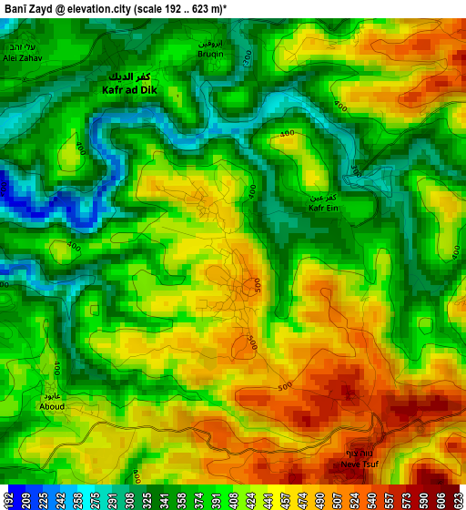
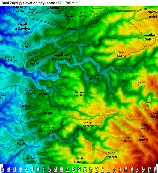
Below is the Elevation map of Banī Zayd, which displays elevation range with different colors. Scale of the first map is from 192 to 623 m (630 to 2044 ft) with average elevation of 405.5 meters (=1330 ft) [note 1]
These maps also provides idea of topography and contour of this city, they are displayed at different zoom levels. More info about maps, scale and edge coordinates you can find below images.
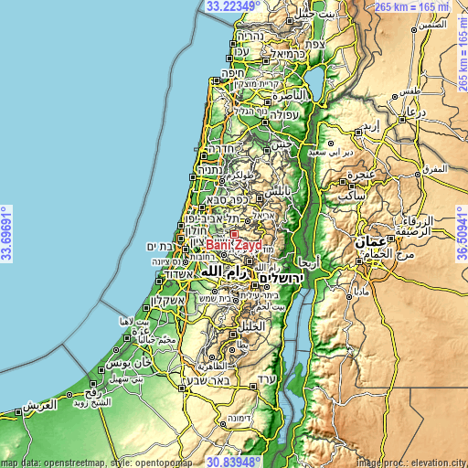
| \ | Map #1 | Map #2 | Topo.Map |
| Scale [m] | 192..623 m | 132..798 m | × |
| Scale [ft] | 630..2044 ft | 433..2618 ft | × |
| Average | 405.5 m = 1330 ft | 405.4 m = 1330 ft | × |
| Width | 8.28 km = 5.1 mi | 16.57 km = 10.3 mi | 265.1 km = 164.7 mi |
| Height | 8.28 km = 5.1 mi | 16.57 km = 10.3 mi | 265.1 km = 164.7 mi |
| ↑Max Latitude | 32.076484° | 32.113713° | 33.22349° |
| Latitude at center | 32.03924° | 32.03924° | 32.03924° |
| ↓Min Latitude | 32.001981° | 31.964706° | 30.83948° |
| ← Min Longitude | 35.059215° | 35.015269° | 33.69691° |
| Longitude center | 35.10316° | 35.10316° | 35.10316° |
| →Max Longitude | 35.147105° | 35.191051° | 36.50941° |
Nearby cities:
Cities around Banī Zayd sort by population:
• Banī Zayd ash Shārqīyah elevation 478 m
6 km,  79°
79°
• Kafr ad Dīk 377 m
3.6 km,  328°
328°
• Brūqīn 368 m
3.7 km,  354°
354°
• Dayr Abū Mash‘al 444 m
5.6 km,  216°
216°
• Al Ittiḩād 558 m
7.2 km,  170°
170°
• Qarāwat Banī Zayd 345 m
3 km,  54°
54°
• Dayr as Sūdān 518 m
4.3 km,  100°
100°
• ‘Ābūd 422 m
4.2 km,  232°
232°
• Rāfāt 306 m
7 km,  307°
307°
• Kafr ‘Ayn 388 m
1.9 km,  60°
60°
• Al Lubban al Gharbī 284 m
6 km,  265°
265°
• Farkhah 586 m
5.7 km, 54°
Multilingual:
 En español:
Banī Zayd elevación 480 m.
 En France:
Banī Zayd élévation 480 m.
 Auf Deutsch:
Banī Zayd höhe über dem Meeresspiegel ist 480 m.

Sources and notes:
- [note 1] Map square and city borders are not equal. Map elevation data is calculated only from area inside that square.
- [src 1] Elevation data from geonames database provided with same terms of usage.
- [src 2] The elevation map of Banī Zayd is generated using elevation data from NASA's 3 arcsec (90m) resolution SRTM data.
- [src 3] Base (background) map © OpenStreetMap contributors tiles are generated by Geofabrik and OpenTopoMap.
Copyright & License:
This Banī Zayd Elevation Map is licensed under CC BY-SA. You may reuse any part from this page, if you give a proper credit by linking to this URL:
 More info on terms of use page.