Aguas Buenas elevation
Aguas Buenas, Puerto Rico elevation is 259 meters and Aguas Buenas elevation in feet is 850 ft above sea level [src 1]. Aguas Buenas is a seat of a first-order administrative division (feature code) with elevation that is 159 meters (522 ft) bigger than average city elevation in Puerto Rico.
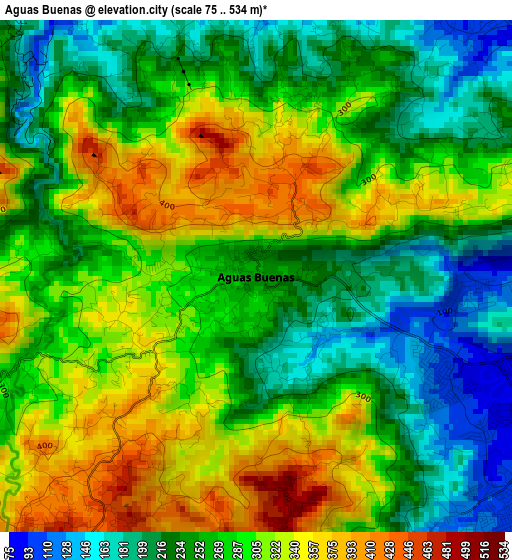
Below is the Elevation map of Aguas Buenas, which displays elevation range with different colors. Scale of the first map is from 75 to 534 m (246 to 1752 ft) with average elevation of 277.2 meters (=909 ft) [note 1]
These maps also provides idea of topography and contour of this city, they are displayed at different zoom levels. More info about maps, scale and edge coordinates you can find below images.
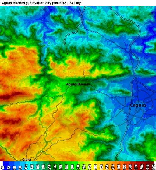
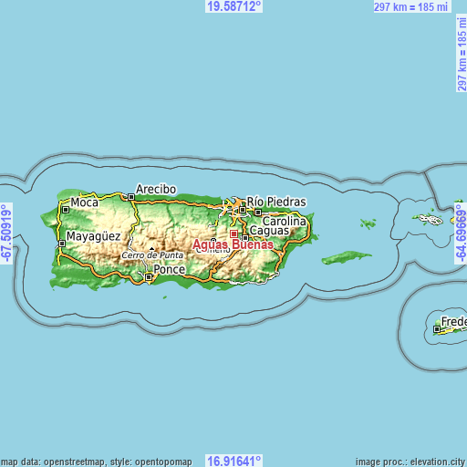
| \ | Map #1 | Map #2 | Topo.Map |
| Scale [m] | 75..534 m | 18..642 m | × |
| Scale [ft] | 246..1752 ft | 59..2106 ft | × |
| Average | 277.2 m = 909 ft | 255.2 m = 837 ft | × |
| Width | 9.28 km = 5.8 mi | 18.56 km = 11.5 mi | 297 km = 184.5 mi |
| Height | 9.28 km = 5.8 mi | 18.56 km = 11.5 mi | 297 km = 184.5 mi |
| ↑Max Latitude | 18.298628° | 18.340346° | 19.58712° |
| Latitude at center | 18.2569° | 18.2569° | 18.2569° |
| ↓Min Latitude | 18.215162° | 18.173414° | 16.91641° |
| ← Min Longitude | -66.146885° | -66.190831° | -67.50919° |
| Longitude center | -66.10294° | -66.10294° | -66.10294° |
| →Max Longitude | -66.058995° | -66.015049° | -64.69669° |
Nearby cities:
Cities around Aguas Buenas sort by population:
• Caguas elevation 65 m
6.3 km,  113°
113°
• Guaynabo 50 m
11.2 km,  355°
355°
• Gurabo 68 m
13.7 km,  91°
91°
• Cidra 426 m
10.9 km,  214°
214°
• Comerío 202 m
13.7 km,  251°
251°
• Celada 84 m
14.6 km,  83°
83°
• Bairoa 64 m
6.6 km, 87°
• G. L. Garcia 443 m
14.4 km,  180°
180°
• Bayamon 445 m
8.9 km,  187°
187°
• Parcelas La Milagrosa 552 m
13.1 km,  223°
223°
• Sumidero 450 m
5.1 km, 212°
• Santa Clara 450 m
5.1 km, 212°
Multilingual:
 En español:
Aguas Buenas elevación 259 m.
 En France:
Aguas Buenas élévation 259 m.
 Auf Deutsch:
Aguas Buenas höhe über dem Meeresspiegel ist 259 m.

Sources and notes:
- [note 1] Map square and city borders are not equal. Map elevation data is calculated only from area inside that square.
- [src 1] Elevation data from geonames database provided with same terms of usage.
- [src 2] The elevation map of Aguas Buenas is generated using elevation data from NASA's 3 arcsec (90m) resolution SRTM data.
- [src 3] Base (background) map © OpenStreetMap contributors tiles are generated by Geofabrik and OpenTopoMap.
Copyright & License:
This Aguas Buenas Elevation Map is licensed under CC BY-SA. You may reuse any part from this page, if you give a proper credit by linking to this URL:
 More info on terms of use page.