Boguty-Pianki elevation
Boguty-Pianki (Mazovia, Powiat ostrowski), Poland elevation is 118 meters and Boguty-Pianki elevation in feet is 387 ft above sea level [src 1]. Boguty-Pianki is a populated place (feature code) with elevation that is 73 meters (240 ft) smaller than average city elevation in Poland.
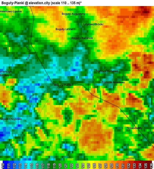
Below is the Elevation map of Boguty-Pianki, which displays elevation range with different colors. Scale of the first map is from 110 to 135 m (361 to 443 ft) with average elevation of 121.7 meters (=399 ft) [note 1]
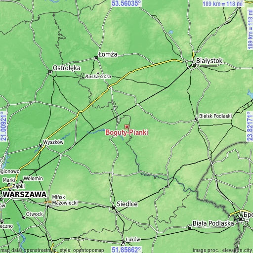
These maps also provides idea of topography and contour of this city, they are displayed at different zoom levels. More info about maps, scale and edge coordinates you can find below images.
| \ | Map #1 | Topo.Map |
| Scale [m] | 110..135 m | × |
| Scale [ft] | 361..443 ft | × |
| Average | 121.7 m = 399 ft | × |
| Width | 5.92 km = 3.7 mi | 189.4 km = 117.7 mi |
| Height | 5.92 km = 3.7 mi | 189.4 km = 117.7 mi |
| ↑Max Latitude | 52.743412° | 53.56035° |
| Latitude at center | 52.7168° | 52.7168° |
| ↓Min Latitude | 52.690172° | 51.85662° |
| ← Min Longitude | 22.371515° | 21.00921° |
| Longitude center | 22.41546° | 22.41546° |
| →Max Longitude | 22.459405° | 23.82171° |
Nearby cities:
Cities around Boguty-Pianki sort by population:
• Wysokie Mazowieckie elevation 143 m
23.2 km,  17°
17°
• Małkinia Górna 101 m
26.2 km,  264°
264°
• Ciechanowiec 116 m
7 km,  127°
127°
• Czyżew 121 m
11.4 km,  322°
322°
• Szepietowo 148 m
19.1 km,  26°
26°
• Kosów Lacki 119 m
22.6 km,  233°
233°
• Rudka 136 m
21 km,  87°
87°
• Sterdyń 121 m
17.3 km,  208°
208°
• Ceranów 111 m
15.8 km, 232°
• Nur 115 m
8.3 km, 229°
• Sabnie 131 m
25.1 km,  196°
196°
• Perlejewo 126 m
19.5 km,  148°
148°
Multilingual:
 En español:
Boguty-Pianki elevación 118 m.
 En France:
Boguty-Pianki élévation 118 m.
 Auf Deutsch:
Boguty-Pianki höhe über dem Meeresspiegel ist 118 m.

Sources and notes:
- [note 1] Map square and city borders are not equal. Map elevation data is calculated only from area inside that square.
- [src 1] Elevation data from geonames database provided with same terms of usage.
- [src 2] The elevation map of Boguty-Pianki is generated using elevation data from NASA's 3 arcsec (90m) resolution SRTM data.
- [src 3] Base (background) map © OpenStreetMap contributors tiles are generated by Geofabrik and OpenTopoMap.
Copyright & License:
This Boguty-Pianki Elevation Map is licensed under CC BY-SA. You may reuse any part from this page, if you give a proper credit by linking to this URL:
 More info on terms of use page.