Kosów Lacki elevation
Kosów Lacki (Mazovia, Powiat sokołowski), Poland elevation is 119 meters and Kosów Lacki elevation in feet is 390 ft above sea level [src 1]. Kosów Lacki is a seat of a third-order administrative division (feature code) with elevation that is 72 meters (236 ft) smaller than average city elevation in Poland.
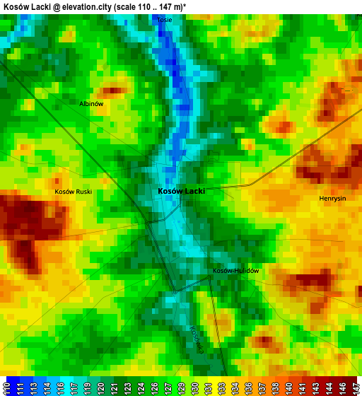
Below is the Elevation map of Kosów Lacki, which displays elevation range with different colors. Scale of the first map is from 110 to 147 m (361 to 482 ft) with average elevation of 128.2 meters (=421 ft) [note 1]
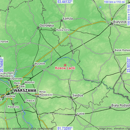
These maps also provides idea of topography and contour of this city, they are displayed at different zoom levels. More info about maps, scale and edge coordinates you can find below images.
| \ | Map #1 | Topo.Map |
| Scale [m] | 110..147 m | × |
| Scale [ft] | 361..482 ft | × |
| Average | 128.2 m = 421 ft | × |
| Width | 5.94 km = 3.7 mi | 190 km = 118.1 mi |
| Height | 5.94 km = 3.7 mi | 189.9 km = 118 mi |
| ↑Max Latitude | 52.622096° | 53.44132° |
| Latitude at center | 52.59541° | 52.59541° |
| ↓Min Latitude | 52.568708° | 51.73285° |
| ← Min Longitude | 22.103125° | 20.74082° |
| Longitude center | 22.14707° | 22.14707° |
| →Max Longitude | 22.191015° | 23.55332° |
Nearby cities:
Cities around Kosów Lacki sort by population:
• Sokołów Podlaski elevation 172 m
22.2 km,  161°
161°
• Węgrów 121 m
23.5 km,  202°
202°
• Małkinia Górna 101 m
13.4 km,  323°
323°
• Brok 106 m
22.7 km,  300°
300°
• Boguty-Pianki 118 m
22.6 km,  53°
53°
• Miedzna 149 m
14.7 km, 195°
• Sadowne 97 m
21 km,  284°
284°
• Stoczek 122 m
17.7 km,  250°
250°
• Sterdyń 121 m
10 km,  99°
99°
• Ceranów 111 m
6.7 km, 54°
• Nur 115 m
14.3 km,  55°
55°
• Sabnie 131 m
15.1 km,  134°
134°
Multilingual:
 En español:
Kosów Lacki elevación 119 m.
 En France:
Kosów Lacki élévation 119 m.
 Auf Deutsch:
Kosów Lacki höhe über dem Meeresspiegel ist 119 m.

Sources and notes:
- [note 1] Map square and city borders are not equal. Map elevation data is calculated only from area inside that square.
- [src 1] Elevation data from geonames database provided with same terms of usage.
- [src 2] The elevation map of Kosów Lacki is generated using elevation data from NASA's 3 arcsec (90m) resolution SRTM data.
- [src 3] Base (background) map © OpenStreetMap contributors tiles are generated by Geofabrik and OpenTopoMap.
Copyright & License:
This Kosów Lacki Elevation Map is licensed under CC BY-SA. You may reuse any part from this page, if you give a proper credit by linking to this URL:
 More info on terms of use page.