Nur elevation
Nur (Mazovia, Powiat ostrowski), Poland elevation is 115 meters and Nur elevation in feet is 377 ft above sea level [src 1]. Nur is a seat of a third-order administrative division (feature code) with elevation that is 76 meters (249 ft) smaller than average city elevation in Poland.
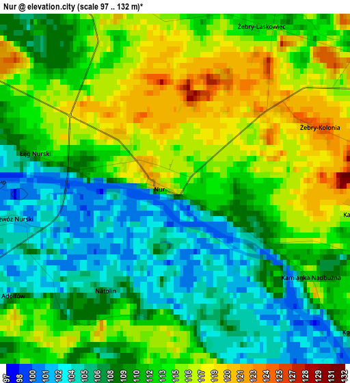
Below is the Elevation map of Nur, which displays elevation range with different colors. Scale of the first map is from 97 to 132 m (318 to 433 ft) with average elevation of 111.5 meters (=366 ft) [note 1]
These maps also provides idea of topography and contour of this city, they are displayed at different zoom levels. More info about maps, scale and edge coordinates you can find below images.
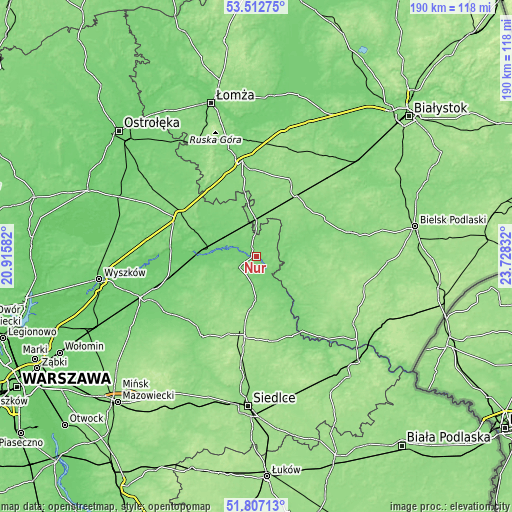
| \ | Map #1 | Topo.Map |
| Scale [m] | 97..132 m | × |
| Scale [ft] | 318..433 ft | × |
| Average | 111.5 m = 366 ft | × |
| Width | 5.93 km = 3.7 mi | 189.6 km = 117.8 mi |
| Height | 5.93 km = 3.7 mi | 189.6 km = 117.8 mi |
| ↑Max Latitude | 52.694902° | 53.51275° |
| Latitude at center | 52.66826° | 52.66826° |
| ↓Min Latitude | 52.641602° | 51.80713° |
| ← Min Longitude | 22.278125° | 20.91582° |
| Longitude center | 22.32207° | 22.32207° |
| →Max Longitude | 22.366015° | 23.72832° |
Nearby cities:
Cities around Nur sort by population:
• Małkinia Górna elevation 101 m
20 km,  277°
277°
• Ciechanowiec 116 m
11.9 km,  84°
84°
• Czyżew 121 m
14.4 km,  357°
357°
• Szepietowo 148 m
27 km,  33°
33°
• Kosów Lacki 119 m
14.3 km,  235°
235°
• Boguty-Pianki 118 m
8.3 km,  49°
49°
• Jabłonna Lacka 134 m
22.8 km,  159°
159°
• Miedzna 149 m
27.3 km,  215°
215°
• Sterdyń 121 m
10 km,  191°
191°
• Ceranów 111 m
7.6 km, 236°
• Sabnie 131 m
18.6 km,  183°
183°
• Perlejewo 126 m
19.9 km,  124°
124°
Multilingual:
 En español:
Nur elevación 115 m.
 En France:
Nur élévation 115 m.


Sources and notes:
- [note 1] Map square and city borders are not equal. Map elevation data is calculated only from area inside that square.
- [src 1] Elevation data from geonames database provided with same terms of usage.
- [src 2] The elevation map of Nur is generated using elevation data from NASA's 3 arcsec (90m) resolution SRTM data.
- [src 3] Base (background) map © OpenStreetMap contributors tiles are generated by Geofabrik and OpenTopoMap.
Copyright & License:
This Nur Elevation Map is licensed under CC BY-SA. You may reuse any part from this page, if you give a proper credit by linking to this URL:
 More info on terms of use page.