Czerwin elevation
Czerwin (Mazovia, Powiat ostrołęcki), Poland elevation is 107 meters and Czerwin elevation in feet is 351 ft above sea level [src 1]. Czerwin is a seat of a third-order administrative division (feature code) with elevation that is 84 meters (276 ft) smaller than average city elevation in Poland.
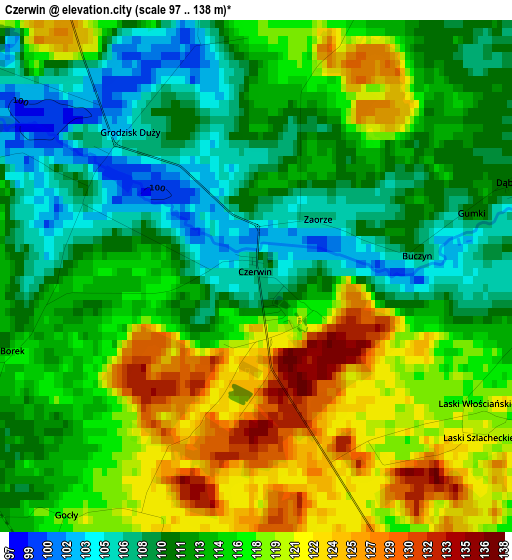
Below is the Elevation map of Czerwin, which displays elevation range with different colors. Scale of the first map is from 97 to 138 m (318 to 453 ft) with average elevation of 114.5 meters (=376 ft) [note 1]
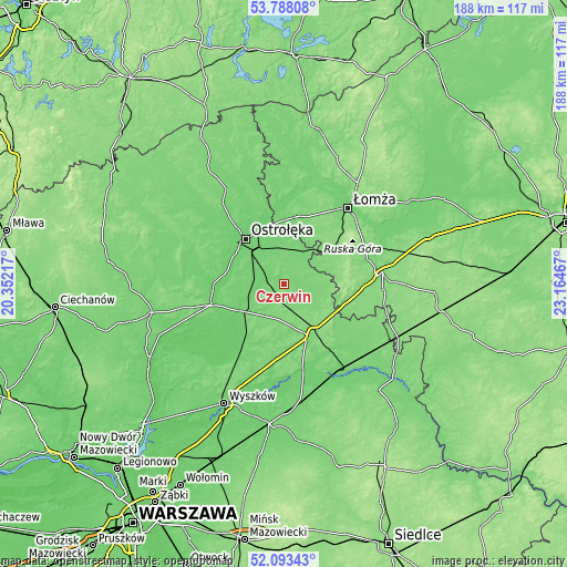
These maps also provides idea of topography and contour of this city, they are displayed at different zoom levels. More info about maps, scale and edge coordinates you can find below images.
| \ | Map #1 | Topo.Map |
| Scale [m] | 97..138 m | × |
| Scale [ft] | 318..453 ft | × |
| Average | 114.5 m = 376 ft | × |
| Width | 5.89 km = 3.7 mi | 188.4 km = 117.1 mi |
| Height | 5.89 km = 3.7 mi | 188.4 km = 117.1 mi |
| ↑Max Latitude | 52.97552° | 53.78808° |
| Latitude at center | 52.94905° | 52.94905° |
| ↓Min Latitude | 52.922564° | 52.09343° |
| ← Min Longitude | 21.714475° | 20.35217° |
| Longitude center | 21.75842° | 21.75842° |
| →Max Longitude | 21.802365° | 23.16467° |
Nearby cities:
Cities around Czerwin sort by population:
• Ostrołęka elevation 97 m
19.5 km,  321°
321°
• Ostrów Mazowiecka 122 m
18.7 km,  150°
150°
• Różan 116 m
25.6 km,  254°
254°
• Długosiodło 102 m
23.8 km,  208°
208°
• Brok 106 m
28.5 km,  166°
166°
• Rzekuń 104 m
14.3 km, 319°
• Śniadowo 126 m
18.5 km,  57°
57°
• Szumowo 133 m
22.1 km,  98°
98°
• Goworowo 97 m
14.6 km, 248°
• Troszyn 110 m
9.3 km,  348°
348°
• Sypniewo 103 m
30.9 km,  281°
281°
• Młynarze 93 m
23.3 km,  271°
271°
Multilingual:
 En español:
Czerwin elevación 107 m.
 En France:
Czerwin élévation 107 m.


Sources and notes:
- [note 1] Map square and city borders are not equal. Map elevation data is calculated only from area inside that square.
- [src 1] Elevation data from geonames database provided with same terms of usage.
- [src 2] The elevation map of Czerwin is generated using elevation data from NASA's 3 arcsec (90m) resolution SRTM data.
- [src 3] Base (background) map © OpenStreetMap contributors tiles are generated by Geofabrik and OpenTopoMap.
Copyright & License:
This Czerwin Elevation Map is licensed under CC BY-SA. You may reuse any part from this page, if you give a proper credit by linking to this URL:
 More info on terms of use page.