Młynarze elevation
Młynarze (Mazovia, Powiat makowski), Poland elevation is 93 meters and Młynarze elevation in feet is 305 ft above sea level [src 1]. Młynarze is a seat of a third-order administrative division (feature code) with elevation that is 98 meters (322 ft) smaller than average city elevation in Poland.
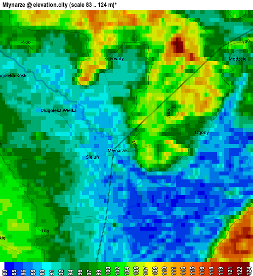
Below is the Elevation map of Młynarze, which displays elevation range with different colors. Scale of the first map is from 83 to 124 m (272 to 407 ft) with average elevation of 96 meters (=315 ft) [note 1]
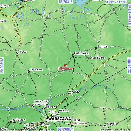
These maps also provides idea of topography and contour of this city, they are displayed at different zoom levels. More info about maps, scale and edge coordinates you can find below images.
| \ | Map #1 | Topo.Map |
| Scale [m] | 83..124 m | × |
| Scale [ft] | 272..407 ft | × |
| Average | 96 m = 315 ft | × |
| Width | 5.89 km = 3.7 mi | 188.4 km = 117.1 mi |
| Height | 5.89 km = 3.7 mi | 188.4 km = 117.1 mi |
| ↑Max Latitude | 52.980637° | 53.7931° |
| Latitude at center | 52.95417° | 52.95417° |
| ↓Min Latitude | 52.927687° | 52.09865° |
| ← Min Longitude | 21.367465° | 20.00516° |
| Longitude center | 21.41141° | 21.41141° |
| →Max Longitude | 21.455355° | 22.81766° |
Nearby cities:
Cities around Młynarze sort by population:
• Ostrołęka elevation 97 m
18.3 km,  36°
36°
• Maków Mazowiecki 99 m
23.1 km,  244°
244°
• Różan 116 m
7.5 km,  190°
190°
• Rzekuń 104 m
17.4 km,  53°
53°
• Krasnosielc 108 m
19.2 km,  297°
297°
• Goworowo 97 m
11.3 km,  121°
121°
• Troszyn 110 m
23 km,  68°
68°
• Sypniewo 103 m
9 km,  309°
309°
• Płoniawy-Bramura 112 m
22.9 km,  276°
276°
• Rzewnie 91 m
14.2 km,  200°
200°
• Szelków 96 m
18.6 km,  224°
224°
• Czerwonka 112 m
14.8 km, 242°
Multilingual:
 En español:
Młynarze elevación 93 m.
 En France:
Młynarze élévation 93 m.


Sources and notes:
- [note 1] Map square and city borders are not equal. Map elevation data is calculated only from area inside that square.
- [src 1] Elevation data from geonames database provided with same terms of usage.
- [src 2] The elevation map of Młynarze is generated using elevation data from NASA's 3 arcsec (90m) resolution SRTM data.
- [src 3] Base (background) map © OpenStreetMap contributors tiles are generated by Geofabrik and OpenTopoMap.
Copyright & License:
This Młynarze Elevation Map is licensed under CC BY-SA. You may reuse any part from this page, if you give a proper credit by linking to this URL:
 More info on terms of use page.