Kowala elevation
Kowala (Mazovia, Powiat radomski), Poland elevation is 191 meters and Kowala elevation in feet is 627 ft above sea level [src 1]. Kowala is a seat of a third-order administrative division (feature code) with elevation that is 0 meters (0 ft) bigger than average city elevation in Poland.
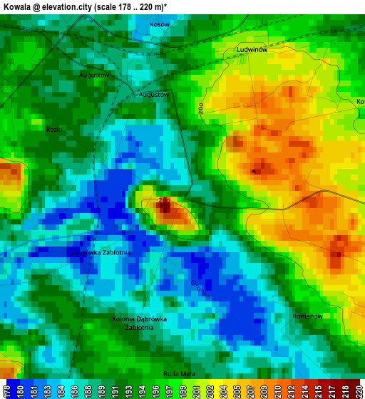
Below is the Elevation map of Kowala, which displays elevation range with different colors. Scale of the first map is from 178 to 220 m (584 to 722 ft) with average elevation of 193.3 meters (=634 ft) [note 1]
These maps also provides idea of topography and contour of this city, they are displayed at different zoom levels. More info about maps, scale and edge coordinates you can find below images.
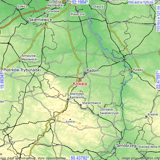
| \ | Map #1 | Topo.Map |
| Scale [m] | 178..220 m | × |
| Scale [ft] | 584..722 ft | × |
| Average | 193.3 m = 634 ft | × |
| Width | 6.11 km = 3.8 mi | 195.4 km = 121.4 mi |
| Height | 6.11 km = 3.8 mi | 195.4 km = 121.4 mi |
| ↑Max Latitude | 51.352483° | 52.1954° |
| Latitude at center | 51.32503° | 51.32503° |
| ↓Min Latitude | 51.29756° | 50.43782° |
| ← Min Longitude | 21.025775° | 19.66347° |
| Longitude center | 21.06972° | 21.06972° |
| →Max Longitude | 21.113665° | 22.47597° |
Nearby cities:
Cities around Kowala sort by population:
• Radom elevation 159 m
10.2 km,  31°
31°
• Szydłowiec 223 m
18.1 km,  233°
233°
• Skaryszew 176 m
12.8 km,  97°
97°
• Wierzbica 203 m
8.5 km,  173°
173°
• Trablice 179 m
5.1 km,  53°
53°
• Orońsko 179 m
5.6 km,  256°
256°
• Przytyk 146 m
19.3 km,  323°
323°
• Jastrząb 192 m
12.1 km,  224°
224°
• Wolanów 184 m
8.9 km,  313°
313°
• Wieniawa 170 m
19.5 km,  282°
282°
• Zakrzew 161 m
13.7 km,  339°
339°
• Mirów 197 m
14.4 km,  190°
190°
Multilingual:
 En español:
Kowala elevación 191 m.
 En France:
Kowala élévation 191 m.


Sources and notes:
- [note 1] Map square and city borders are not equal. Map elevation data is calculated only from area inside that square.
- [src 1] Elevation data from geonames database provided with same terms of usage.
- [src 2] The elevation map of Kowala is generated using elevation data from NASA's 3 arcsec (90m) resolution SRTM data.
- [src 3] Base (background) map © OpenStreetMap contributors tiles are generated by Geofabrik and OpenTopoMap.
Copyright & License:
This Kowala Elevation Map is licensed under CC BY-SA. You may reuse any part from this page, if you give a proper credit by linking to this URL:
 More info on terms of use page.