Mirów elevation
Mirów (Mazovia, Powiat szydłowiecki), Poland elevation is 197 meters and Mirów elevation in feet is 646 ft above sea level [src 1]. Mirów is a seat of a third-order administrative division (feature code) with elevation that is 6 meters (20 ft) bigger than average city elevation in Poland.
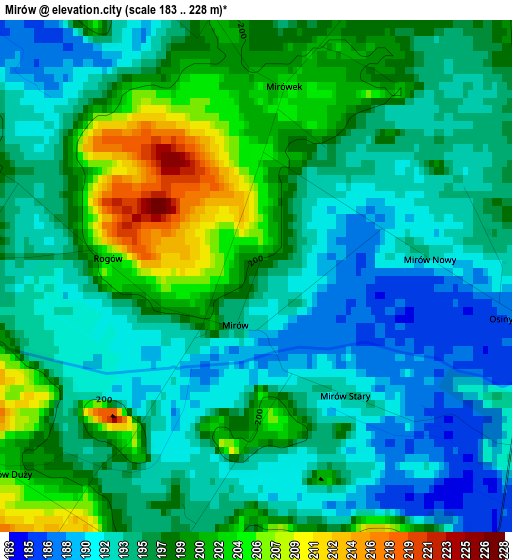
Below is the Elevation map of Mirów, which displays elevation range with different colors. Scale of the first map is from 183 to 228 m (600 to 748 ft) with average elevation of 196 meters (=643 ft) [note 1]
These maps also provides idea of topography and contour of this city, they are displayed at different zoom levels. More info about maps, scale and edge coordinates you can find below images.
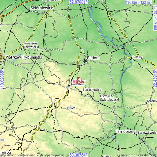
| \ | Map #1 | Topo.Map |
| Scale [m] | 183..228 m | × |
| Scale [ft] | 600..748 ft | × |
| Average | 196 m = 643 ft | × |
| Width | 6.12 km = 3.8 mi | 196 km = 121.8 mi |
| Height | 6.12 km = 3.8 mi | 196 km = 121.8 mi |
| ↑Max Latitude | 51.22473° | 52.07001° |
| Latitude at center | 51.1972° | 51.1972° |
| ↓Min Latitude | 51.169654° | 50.30754° |
| ← Min Longitude | 20.988955° | 19.62665° |
| Longitude center | 21.0329° | 21.0329° |
| →Max Longitude | 21.076845° | 22.43915° |
Nearby cities:
Cities around Mirów sort by population:
• Skarżysko-Kamienna elevation 238 m
14.6 km,  230°
230°
• Szydłowiec 223 m
12.5 km,  286°
286°
• Iłża 182 m
14.9 km,  104°
104°
• Wierzbica 203 m
6.8 km,  30°
30°
• Wąchock 215 m
13.8 km,  185°
185°
• Skarżysko Kościelne 234 m
10.7 km, 232°
• Mirzec 214 m
7.2 km,  166°
166°
• Wielka Wieś 286 m
14.8 km,  198°
198°
• Orońsko 179 m
13.2 km,  347°
347°
• Grzybowa Góra 246 m
8.7 km,  214°
214°
• Kowala 191 m
14.4 km,  10°
10°
• Jastrząb 192 m
8.1 km,  313°
313°
Multilingual:
 En español:
Mirów elevación 197 m.
 En France:
Mirów élévation 197 m.


Sources and notes:
- [note 1] Map square and city borders are not equal. Map elevation data is calculated only from area inside that square.
- [src 1] Elevation data from geonames database provided with same terms of usage.
- [src 2] The elevation map of Mirów is generated using elevation data from NASA's 3 arcsec (90m) resolution SRTM data.
- [src 3] Base (background) map © OpenStreetMap contributors tiles are generated by Geofabrik and OpenTopoMap.
Copyright & License:
This Mirów Elevation Map is licensed under CC BY-SA. You may reuse any part from this page, if you give a proper credit by linking to this URL:
 More info on terms of use page.