Mszana Górna elevation
Mszana Górna (Lesser Poland, Powiat limanowski), Poland elevation is 411 meters and Mszana Górna elevation in feet is 1348 ft above sea level [src 1]. Mszana Górna is a populated place (feature code) with elevation that is 220 meters (722 ft) bigger than average city elevation in Poland.
Below is the Elevation map of Mszana Górna, which displays elevation range with different colors. Scale of the first map is from 374 to 755 m (1227 to 2477 ft) with average elevation of 499.3 meters (=1638 ft) [note 1]
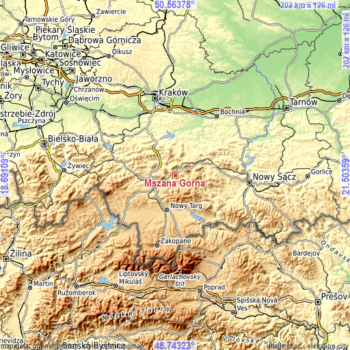
These maps also provides idea of topography and contour of this city, they are displayed at different zoom levels. More info about maps, scale and edge coordinates you can find below images.
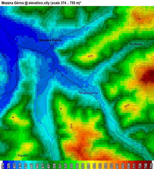
| \ | Map #1 | Topo.Map |
| Scale [m] | 374..755 m | × |
| Scale [ft] | 1227..2477 ft | × |
| Average | 499.3 m = 1638 ft | × |
| Width | 6.33 km = 3.9 mi | 202.4 km = 125.8 mi |
| Height | 6.33 km = 3.9 mi | 202.4 km = 125.8 mi |
| ↑Max Latitude | 49.690457° | 50.56378° |
| Latitude at center | 49.66202° | 49.66202° |
| ↓Min Latitude | 49.633566° | 48.74323° |
| ← Min Longitude | 20.053395° | 18.69109° |
| Longitude center | 20.09734° | 20.09734° |
| →Max Longitude | 20.141285° | 21.50359° |
Nearby cities:
Cities around Mszana Górna sort by population:
• Rabka-Zdrój elevation 494 m
11.1 km,  237°
237°
• Mszana Dolna 395 m
1.9 km,  317°
317°
• Pcim 324 m
13.5 km, 317°
• Lubień 347 m
10.7 km,  306°
306°
• Dobra 448 m
12.8 km,  61°
61°
• Kasina Wielka 496 m
8 km,  20°
20°
• Wiśniowa 358 m
14 km,  5°
5°
• Lubomierz 596 m
9.6 km,  128°
128°
• Olszówka 488 m
7.2 km,  223°
223°
• Niedźwiedź 495 m
4.8 km,  197°
197°
• Skrzydlna 421 m
12 km,  32°
32°
• Węglówka 436 m
8.1 km,  354°
354°
Multilingual:
 En español:
Mszana Górna elevación 411 m.
 En France:
Mszana Górna élévation 411 m.
 Auf Deutsch:
Mszana Górna höhe über dem Meeresspiegel ist 411 m.

Sources and notes:
- [note 1] Map square and city borders are not equal. Map elevation data is calculated only from area inside that square.
- [src 1] Elevation data from geonames database provided with same terms of usage.
- [src 2] The elevation map of Mszana Górna is generated using elevation data from NASA's 3 arcsec (90m) resolution SRTM data.
- [src 3] Base (background) map © OpenStreetMap contributors tiles are generated by Geofabrik and OpenTopoMap.
Copyright & License:
This Mszana Górna Elevation Map is licensed under CC BY-SA. You may reuse any part from this page, if you give a proper credit by linking to this URL:
 More info on terms of use page.