Pcim elevation
Pcim (Lesser Poland, Powiat myślenicki), Poland elevation is 324 meters and Pcim elevation in feet is 1063 ft above sea level [src 1]. Pcim is a seat of a third-order administrative division (feature code) with elevation that is 133 meters (436 ft) bigger than average city elevation in Poland.
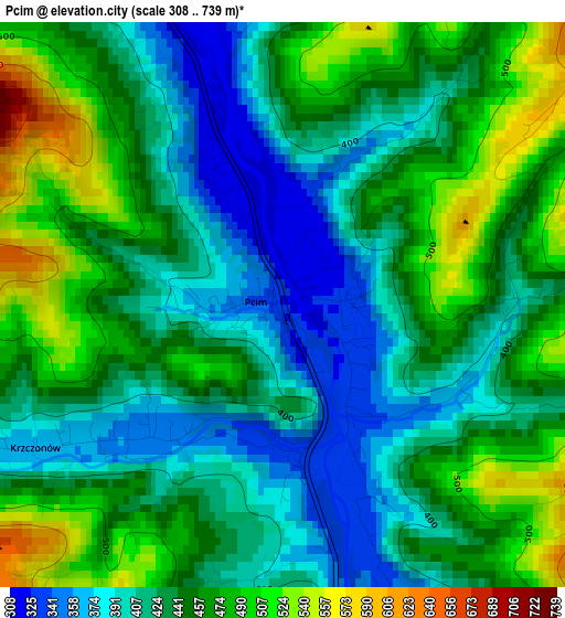
Below is the Elevation map of Pcim, which displays elevation range with different colors. Scale of the first map is from 308 to 739 m (1010 to 2425 ft) with average elevation of 441 meters (=1447 ft) [note 1]
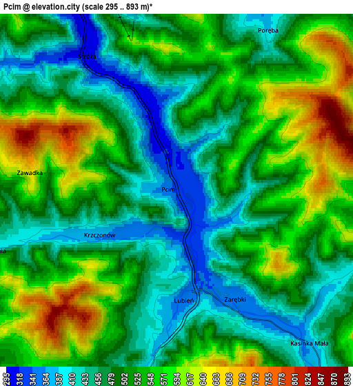
These maps also provides idea of topography and contour of this city, they are displayed at different zoom levels. More info about maps, scale and edge coordinates you can find below images.
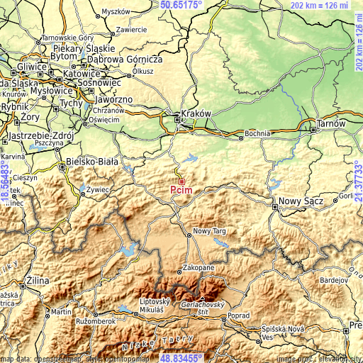
| \ | Map #1 | Map #2 | Topo.Map |
| Scale [m] | 308..739 m | 295..893 m | × |
| Scale [ft] | 1010..2425 ft | 968..2930 ft | × |
| Average | 441 m = 1447 ft | 509.9 m = 1673 ft | × |
| Width | 6.31 km = 3.9 mi | 12.63 km = 7.8 mi | 202.1 km = 125.6 mi |
| Height | 6.31 km = 3.9 mi | 12.63 km = 7.8 mi | 202 km = 125.5 mi |
| ↑Max Latitude | 49.780045° | 49.808413° | 50.65175° |
| Latitude at center | 49.75166° | 49.75166° | 49.75166° |
| ↓Min Latitude | 49.723259° | 49.69484° | 48.83455° |
| ← Min Longitude | 19.927135° | 19.883189° | 18.56483° |
| Longitude center | 19.97108° | 19.97108° | 19.97108° |
| →Max Longitude | 20.015025° | 20.058971° | 21.37733° |
Nearby cities:
Cities around Pcim sort by population:
• Myślenice elevation 304 m
9.4 km,  345°
345°
• Lubień 347 m
3.6 km,  171°
171°
• Tokarnia 417 m
7.6 km,  249°
249°
• Stróża 302 m
6 km,  325°
325°
• Łętownia 467 m
9.4 km,  230°
230°
• Trzemeśnia 311 m
9.2 km,  23°
23°
• Trzebunia 406 m
9.9 km,  296°
296°
• Krzczonów 379 m
4.1 km, 248°
• Osieczany 273 m
10.1 km,  4°
4°
• Lipnik 420 m
9.1 km,  62°
62°
• Poręba 413 m
6 km,  33°
33°
• Węglówka 436 m
8.5 km,  103°
103°
Multilingual:
 En español:
Pcim elevación 324 m.
 En France:
Pcim élévation 324 m.


Sources and notes:
- [note 1] Map square and city borders are not equal. Map elevation data is calculated only from area inside that square.
- [src 1] Elevation data from geonames database provided with same terms of usage.
- [src 2] The elevation map of Pcim is generated using elevation data from NASA's 3 arcsec (90m) resolution SRTM data.
- [src 3] Base (background) map © OpenStreetMap contributors tiles are generated by Geofabrik and OpenTopoMap.
Copyright & License:
This Pcim Elevation Map is licensed under CC BY-SA. You may reuse any part from this page, if you give a proper credit by linking to this URL:
 More info on terms of use page.