Myślenice elevation
Myślenice (Lesser Poland, Powiat myślenicki), Poland elevation is 304 meters and Myślenice elevation in feet is 997 ft above sea level [src 1]. Myślenice is a seat of a second-order administrative division (feature code) with elevation that is 113 meters (371 ft) bigger than average city elevation in Poland.
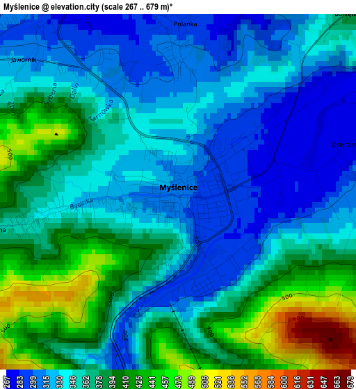
Below is the Elevation map of Myślenice, which displays elevation range with different colors. Scale of the first map is from 267 to 679 m (876 to 2228 ft) with average elevation of 360.7 meters (=1183 ft) [note 1]
These maps also provides idea of topography and contour of this city, they are displayed at different zoom levels. More info about maps, scale and edge coordinates you can find below images.
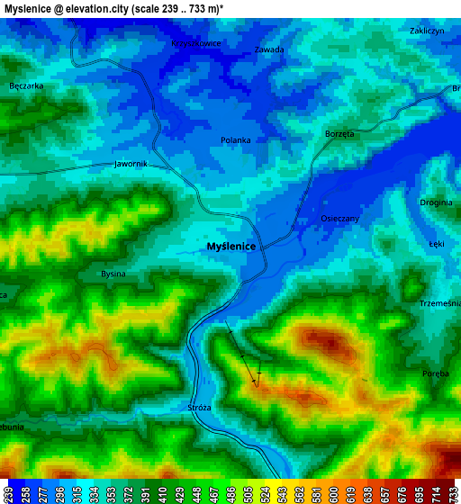
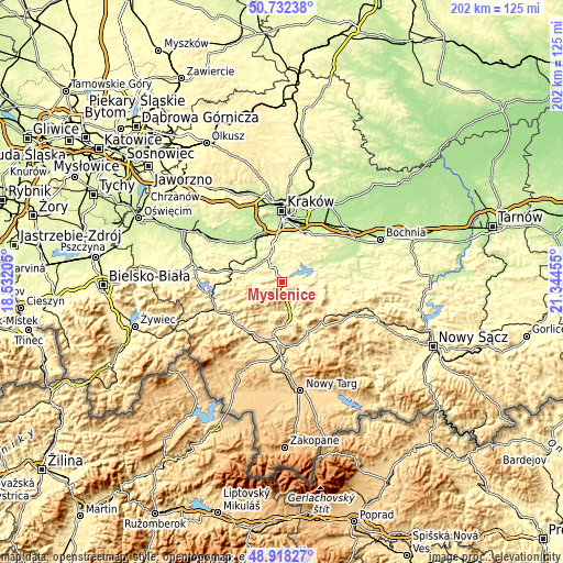
| \ | Map #1 | Map #2 | Topo.Map |
| Scale [m] | 267..679 m | 239..733 m | × |
| Scale [ft] | 876..2228 ft | 784..2405 ft | × |
| Average | 360.7 m = 1183 ft | 380.3 m = 1248 ft | × |
| Width | 6.3 km = 3.9 mi | 12.61 km = 7.8 mi | 201.7 km = 125.3 mi |
| Height | 6.3 km = 3.9 mi | 12.61 km = 7.8 mi | 201.7 km = 125.3 mi |
| ↑Max Latitude | 49.862167° | 49.890487° | 50.73238° |
| Latitude at center | 49.83383° | 49.83383° | 49.83383° |
| ↓Min Latitude | 49.805477° | 49.777107° | 48.91827° |
| ← Min Longitude | 19.894355° | 19.850409° | 18.53205° |
| Longitude center | 19.9383° | 19.9383° | 19.9383° |
| →Max Longitude | 19.982245° | 20.026191° | 21.34455° |
Nearby cities:
Cities around Myślenice sort by population:
• Stróża elevation 302 m
4.3 km,  194°
194°
• Jawornik 309 m
4.1 km,  307°
307°
• Głogoczów 237 m
8.2 km,  325°
325°
• Rudnik 327 m
6.8 km,  287°
287°
• Trzemeśnia 311 m
6 km,  96°
96°
• Trzebunia 406 m
8.1 km,  234°
234°
• Krzyszkowice 251 m
5.6 km,  348°
348°
• Osieczany 273 m
3.3 km,  72°
72°
• Jasienica 360 m
7 km,  259°
259°
• Borzęta 377 m
4.3 km,  42°
42°
• Poręba 413 m
7 km,  126°
126°
• Bęczarka 321 m
7.1 km, 313°
Multilingual:
 En español:
Myślenice elevación 304 m.
 En France:
Myślenice élévation 304 m.
 Auf Deutsch:
Myślenice höhe über dem Meeresspiegel ist 304 m.

Sources and notes:
- [note 1] Map square and city borders are not equal. Map elevation data is calculated only from area inside that square.
- [src 1] Elevation data from geonames database provided with same terms of usage.
- [src 2] The elevation map of Myślenice is generated using elevation data from NASA's 3 arcsec (90m) resolution SRTM data.
- [src 3] Base (background) map © OpenStreetMap contributors tiles are generated by Geofabrik and OpenTopoMap.
Copyright & License:
This Myślenice Elevation Map is licensed under CC BY-SA. You may reuse any part from this page, if you give a proper credit by linking to this URL:
 More info on terms of use page.