Łętownia elevation
Łętownia (Lesser Poland, Powiat suski), Poland elevation is 467 meters and Łętownia elevation in feet is 1532 ft above sea level [src 1]. Łętownia is a populated place (feature code) with elevation that is 276 meters (906 ft) bigger than average city elevation in Poland.
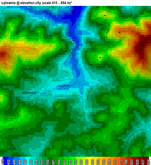
Below is the Elevation map of Łętownia, which displays elevation range with different colors. Scale of the first map is from 415 to 854 m (1362 to 2802 ft) with average elevation of 569.5 meters (=1868 ft) [note 1]
These maps also provides idea of topography and contour of this city, they are displayed at different zoom levels. More info about maps, scale and edge coordinates you can find below images.
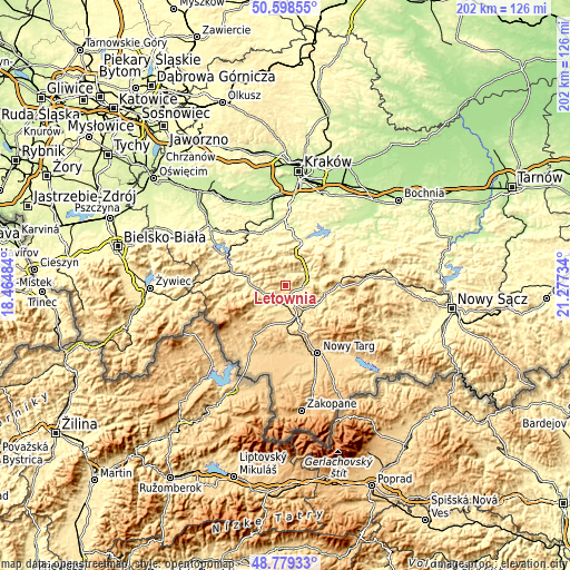
| \ | Map #1 | Topo.Map |
| Scale [m] | 415..854 m | × |
| Scale [ft] | 1362..2802 ft | × |
| Average | 569.5 m = 1868 ft | × |
| Width | 6.32 km = 3.9 mi | 202.3 km = 125.7 mi |
| Height | 6.32 km = 3.9 mi | 202.3 km = 125.7 mi |
| ↑Max Latitude | 49.725867° | 50.59855° |
| Latitude at center | 49.69745° | 49.69745° |
| ↓Min Latitude | 49.669017° | 48.77933° |
| ← Min Longitude | 19.827145° | 18.46484° |
| Longitude center | 19.87109° | 19.87109° |
| →Max Longitude | 19.915035° | 21.27734° |
Nearby cities:
Cities around Łętownia sort by population:
• Jordanów elevation 497 m
6.1 km,  209°
209°
• Pcim 324 m
9.4 km,  50°
50°
• Lubień 347 m
8.1 km,  72°
72°
• Tokarnia 417 m
3.3 km,  0°
0°
• Osielec 466 m
6.6 km,  253°
253°
• Bystra 446 m
8.6 km,  230°
230°
• Bieńkówka 489 m
11.3 km,  320°
320°
• Naprawa 534 m
5.7 km,  174°
174°
• Trzebunia 406 m
10.6 km,  350°
350°
• Krzczonów 379 m
5.7 km,  36°
36°
• Toporzysko 484 m
9.5 km, 211°
• Skomielna Czarna 477 m
4.1 km, 322°
Multilingual:
 En español:
Łętownia elevación 467 m.
 En France:
Łętownia élévation 467 m.
 Auf Deutsch:
Łętownia höhe über dem Meeresspiegel ist 467 m.

Sources and notes:
- [note 1] Map square and city borders are not equal. Map elevation data is calculated only from area inside that square.
- [src 1] Elevation data from geonames database provided with same terms of usage.
- [src 2] The elevation map of Łętownia is generated using elevation data from NASA's 3 arcsec (90m) resolution SRTM data.
- [src 3] Base (background) map © OpenStreetMap contributors tiles are generated by Geofabrik and OpenTopoMap.
Copyright & License:
This Łętownia Elevation Map is licensed under CC BY-SA. You may reuse any part from this page, if you give a proper credit by linking to this URL:
 More info on terms of use page.