Bieńkówka elevation
Bieńkówka (Lesser Poland, Powiat suski), Poland elevation is 489 meters and Bieńkówka elevation in feet is 1604 ft above sea level [src 1]. Bieńkówka is a populated place (feature code) with elevation that is 298 meters (978 ft) bigger than average city elevation in Poland.
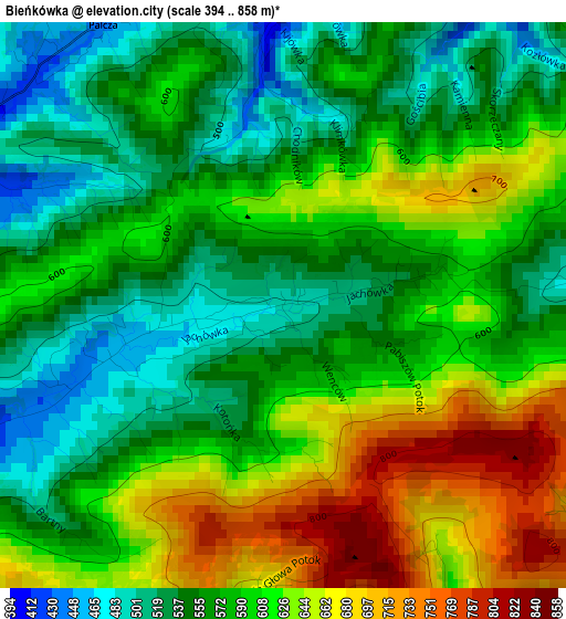
Below is the Elevation map of Bieńkówka, which displays elevation range with different colors. Scale of the first map is from 394 to 858 m (1293 to 2815 ft) with average elevation of 589.9 meters (=1935 ft) [note 1]
These maps also provides idea of topography and contour of this city, they are displayed at different zoom levels. More info about maps, scale and edge coordinates you can find below images.
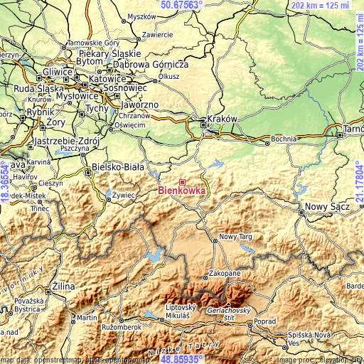
| \ | Map #1 | Topo.Map |
| Scale [m] | 394..858 m | × |
| Scale [ft] | 1293..2815 ft | × |
| Average | 589.9 m = 1935 ft | × |
| Width | 6.31 km = 3.9 mi | 202 km = 125.5 mi |
| Height | 6.31 km = 3.9 mi | 201.9 km = 125.5 mi |
| ↑Max Latitude | 49.804371° | 50.67563° |
| Latitude at center | 49.776° | 49.776° |
| ↓Min Latitude | 49.747613° | 48.85935° |
| ← Min Longitude | 19.727845° | 18.36554° |
| Longitude center | 19.77179° | 19.77179° |
| →Max Longitude | 19.815735° | 21.17804° |
Nearby cities:
Cities around Bieńkówka sort by population:
• Sułkowice elevation 290 m
7.5 km,  16°
16°
• Maków Podhalański 361 m
8.5 km,  233°
233°
• Tokarnia 417 m
9 km,  127°
127°
• Budzów 351 m
7.1 km,  270°
270°
• Lanckorona 466 m
8.7 km,  332°
332°
• Trzebunia 406 m
5.7 km,  72°
72°
• Skawinki 376 m
6.7 km,  320°
320°
• Harbutowice 362 m
4.1 km,  8°
8°
• Jasienica 360 m
7.2 km,  44°
44°
• Skomielna Czarna 477 m
7.1 km,  139°
139°
• Stronie 419 m
9.2 km,  311°
311°
• Palcza 442 m
3.8 km, 327°
Multilingual:
 En español:
Bieńkówka elevación 489 m.
 En France:
Bieńkówka élévation 489 m.
 Auf Deutsch:
Bieńkówka höhe über dem Meeresspiegel ist 489 m.

Sources and notes:
- [note 1] Map square and city borders are not equal. Map elevation data is calculated only from area inside that square.
- [src 1] Elevation data from geonames database provided with same terms of usage.
- [src 2] The elevation map of Bieńkówka is generated using elevation data from NASA's 3 arcsec (90m) resolution SRTM data.
- [src 3] Base (background) map © OpenStreetMap contributors tiles are generated by Geofabrik and OpenTopoMap.
Copyright & License:
This Bieńkówka Elevation Map is licensed under CC BY-SA. You may reuse any part from this page, if you give a proper credit by linking to this URL:
 More info on terms of use page.