Dobra elevation
Dobra (Lesser Poland, Powiat limanowski), Poland elevation is 448 meters and Dobra elevation in feet is 1470 ft above sea level [src 1]. Dobra is a seat of a third-order administrative division (feature code) with elevation that is 257 meters (843 ft) bigger than average city elevation in Poland.
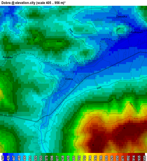
Below is the Elevation map of Dobra, which displays elevation range with different colors. Scale of the first map is from 405 to 956 m (1329 to 3136 ft) with average elevation of 564.7 meters (=1853 ft) [note 1]
These maps also provides idea of topography and contour of this city, they are displayed at different zoom levels. More info about maps, scale and edge coordinates you can find below images.
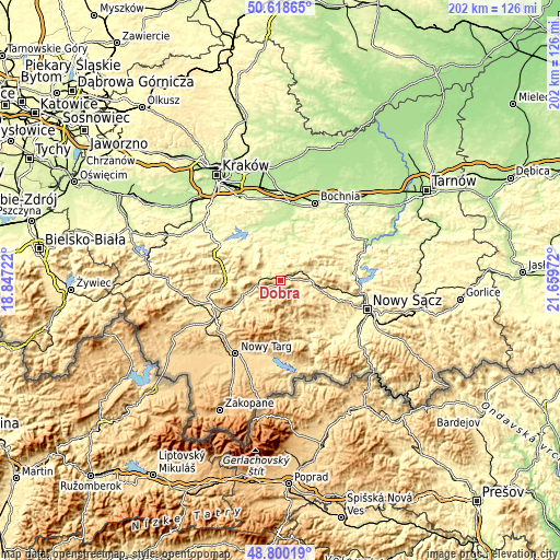
| \ | Map #1 | Topo.Map |
| Scale [m] | 405..956 m | × |
| Scale [ft] | 1329..3136 ft | × |
| Average | 564.7 m = 1853 ft | × |
| Width | 6.32 km = 3.9 mi | 202.2 km = 125.6 mi |
| Height | 6.32 km = 3.9 mi | 202.2 km = 125.6 mi |
| ↑Max Latitude | 49.746335° | 50.61865° |
| Latitude at center | 49.71793° | 49.71793° |
| ↓Min Latitude | 49.689509° | 48.80019° |
| ← Min Longitude | 20.209525° | 18.84722° |
| Longitude center | 20.25347° | 20.25347° |
| →Max Longitude | 20.297415° | 21.65972° |
Nearby cities:
Cities around Dobra sort by population:
• Limanowa elevation 408 m
12.2 km,  96°
96°
• Mszana Dolna 395 m
13.4 km,  248°
248°
• Słopnice 465 m
7.4 km,  119°
119°
• Laskowa 332 m
15 km,  71°
71°
• Kasina Wielka 496 m
8.6 km,  278°
278°
• Tymbark 427 m
5.3 km,  77°
77°
• Mszana Górna 411 m
12.8 km,  241°
241°
• Wiśniowa 358 m
12.6 km,  307°
307°
• Lubomierz 596 m
12.7 km,  196°
196°
• Lipnik 420 m
14.5 km,  303°
303°
• Węglówka 436 m
12.2 km, 278°
• Skrzydlna 421 m
6.2 km, 309°
Multilingual:
 En español:
Dobra elevación 448 m.
 En France:
Dobra élévation 448 m.


Sources and notes:
- [note 1] Map square and city borders are not equal. Map elevation data is calculated only from area inside that square.
- [src 1] Elevation data from geonames database provided with same terms of usage.
- [src 2] The elevation map of Dobra is generated using elevation data from NASA's 3 arcsec (90m) resolution SRTM data.
- [src 3] Base (background) map © OpenStreetMap contributors tiles are generated by Geofabrik and OpenTopoMap.
Copyright & License:
This Dobra Elevation Map is licensed under CC BY-SA. You may reuse any part from this page, if you give a proper credit by linking to this URL:
 More info on terms of use page.