Obrazów elevation
Obrazów (Świętokrzyskie, Powiat sandomierski), Poland elevation is 194 meters and Obrazów elevation in feet is 636 ft above sea level [src 1]. Obrazów is a seat of a third-order administrative division (feature code) with elevation that is 3 meters (10 ft) bigger than average city elevation in Poland.
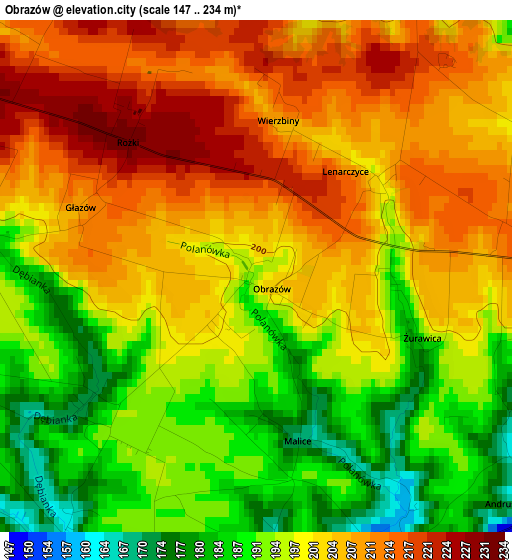
Below is the Elevation map of Obrazów, which displays elevation range with different colors. Scale of the first map is from 147 to 234 m (482 to 768 ft) with average elevation of 200.2 meters (=657 ft) [note 1]
These maps also provides idea of topography and contour of this city, they are displayed at different zoom levels. More info about maps, scale and edge coordinates you can find below images.
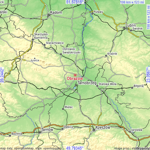
| \ | Map #1 | Topo.Map |
| Scale [m] | 147..234 m | × |
| Scale [ft] | 482..768 ft | × |
| Average | 200.2 m = 657 ft | × |
| Width | 6.19 km = 3.8 mi | 198.1 km = 123.1 mi |
| Height | 6.19 km = 3.8 mi | 198.1 km = 123.1 mi |
| ↑Max Latitude | 50.72059° | 51.57515° |
| Latitude at center | 50.69276° | 50.69276° |
| ↓Min Latitude | 50.664913° | 49.79345° |
| ← Min Longitude | 21.606505° | 20.2442° |
| Longitude center | 21.65045° | 21.65045° |
| →Max Longitude | 21.694395° | 23.0567° |
Nearby cities:
Cities around Obrazów sort by population:
• Tarnobrzeg elevation 162 m
13.5 km,  171°
171°
• Sandomierz 185 m
7 km,  99°
99°
• Gorzyce 141 m
13.7 km, 102°
• Koprzywnica 165 m
12 km,  203°
203°
• Klimontów 210 m
14.3 km,  253°
253°
• Sokolniki 142 m
12.6 km,  118°
118°
• Dwikozy 148 m
10.9 km,  63°
63°
• Wilczyce 164 m
6 km,  4°
4°
• Samborzec 152 m
5.1 km,  181°
181°
• Łoniów 172 m
16.8 km,  211°
211°
• Lipnik 256 m
11.8 km,  290°
290°
• Wojciechowice 189 m
17.2 km,  345°
345°
Multilingual:
 En español:
Obrazów elevación 194 m.
 En France:
Obrazów élévation 194 m.


Sources and notes:
- [note 1] Map square and city borders are not equal. Map elevation data is calculated only from area inside that square.
- [src 1] Elevation data from geonames database provided with same terms of usage.
- [src 2] The elevation map of Obrazów is generated using elevation data from NASA's 3 arcsec (90m) resolution SRTM data.
- [src 3] Base (background) map © OpenStreetMap contributors tiles are generated by Geofabrik and OpenTopoMap.
Copyright & License:
This Obrazów Elevation Map is licensed under CC BY-SA. You may reuse any part from this page, if you give a proper credit by linking to this URL:
 More info on terms of use page.