Olsztynek elevation
Olsztynek (Warmia-Masuria, Powiat olsztyński), Poland elevation is 169 meters and Olsztynek elevation in feet is 554 ft above sea level [src 1]. Olsztynek is a seat of a third-order administrative division (feature code) with elevation that is 22 meters (72 ft) smaller than average city elevation in Poland.
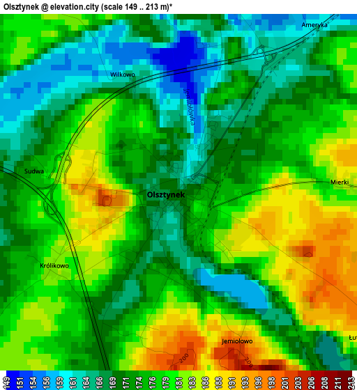
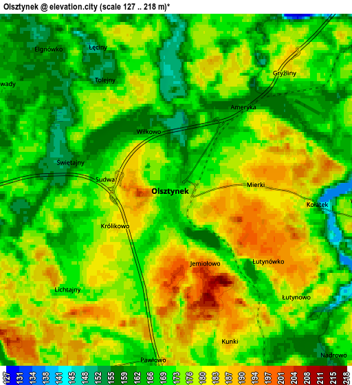
Below is the Elevation map of Olsztynek, which displays elevation range with different colors. Scale of the first map is from 149 to 213 m (489 to 699 ft) with average elevation of 175.1 meters (=574 ft) [note 1]
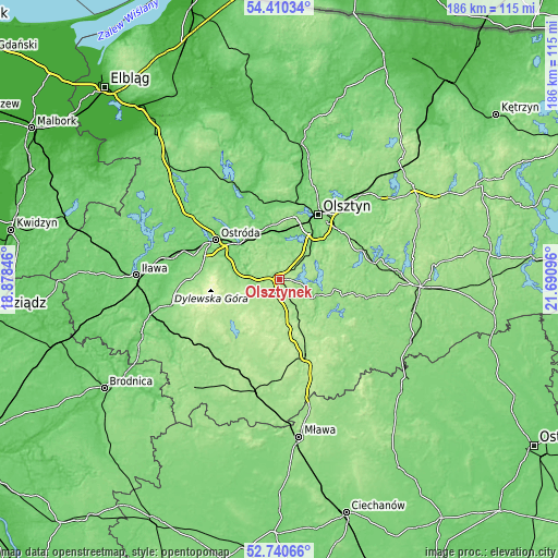
These maps also provides idea of topography and contour of this city, they are displayed at different zoom levels. More info about maps, scale and edge coordinates you can find below images.
| \ | Map #1 | Map #2 | Topo.Map |
| Scale [m] | 149..213 m | 127..218 m | × |
| Scale [ft] | 489..699 ft | 417..715 ft | × |
| Average | 175.1 m = 574 ft | 172.7 m = 567 ft | × |
| Width | 5.8 km = 3.6 mi | 11.6 km = 7.2 mi | 185.7 km = 115.4 mi |
| Height | 5.8 km = 3.6 mi | 11.6 km = 7.2 mi | 185.6 km = 115.3 mi |
| ↑Max Latitude | 53.60982° | 53.635884° | 54.41034° |
| Latitude at center | 53.58374° | 53.58374° | 53.58374° |
| ↓Min Latitude | 53.557644° | 53.531532° | 52.74066° |
| ← Min Longitude | 20.240765° | 20.196819° | 18.87846° |
| Longitude center | 20.28471° | 20.28471° | 20.28471° |
| →Max Longitude | 20.328655° | 20.372601° | 21.69096° |
Nearby cities:
Cities around Olsztynek sort by population:
• Olsztyn elevation 139 m
25.8 km,  32°
32°
• Ostróda 111 m
24.5 km,  300°
300°
• Nidzica 175 m
26.6 km,  159°
159°
• Kozłowo 179 m
30.8 km,  179°
179°
• Dywity 132 m
31 km,  24°
24°
• Jonkowo 134 m
27.2 km,  3°
3°
• Stawiguda 148 m
11.2 km,  43°
43°
• Dąbrówno 170 m
23.4 km,  224°
224°
• Jedwabno 139 m
29.8 km,  101°
101°
• Kortowo 116 m
22.4 km, 30°
• Gietrzwałd 108 m
18.3 km,  350°
350°
• Gierzwałd 193 m
13.8 km,  249°
249°
Multilingual:
 En español:
Olsztynek elevación 169 m.
 En France:
Olsztynek élévation 169 m.
 Auf Deutsch:
Hohenstein höhe über dem Meeresspiegel ist 169 m.

Sources and notes:
- [note 1] Map square and city borders are not equal. Map elevation data is calculated only from area inside that square.
- [src 1] Elevation data from geonames database provided with same terms of usage.
- [src 2] The elevation map of Olsztynek is generated using elevation data from NASA's 3 arcsec (90m) resolution SRTM data.
- [src 3] Base (background) map © OpenStreetMap contributors tiles are generated by Geofabrik and OpenTopoMap.
Copyright & License:
This Olsztynek Elevation Map is licensed under CC BY-SA. You may reuse any part from this page, if you give a proper credit by linking to this URL:
 More info on terms of use page.