Dywity elevation
Dywity (Warmia-Masuria, Powiat olsztyński), Poland elevation is 132 meters and Dywity elevation in feet is 433 ft above sea level [src 1]. Dywity is a populated place (feature code) with elevation that is 59 meters (194 ft) smaller than average city elevation in Poland.
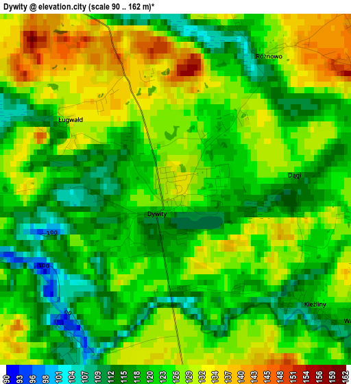
Below is the Elevation map of Dywity, which displays elevation range with different colors. Scale of the first map is from 90 to 162 m (295 to 531 ft) with average elevation of 124 meters (=407 ft) [note 1]
These maps also provides idea of topography and contour of this city, they are displayed at different zoom levels. More info about maps, scale and edge coordinates you can find below images.
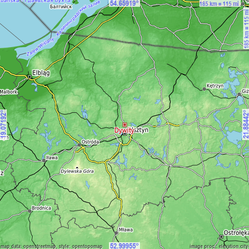
| \ | Map #1 | Topo.Map |
| Scale [m] | 90..162 m | × |
| Scale [ft] | 295..531 ft | × |
| Average | 124 m = 407 ft | × |
| Width | 5.77 km = 3.6 mi | 184.5 km = 114.6 mi |
| Height | 5.77 km = 3.6 mi | 184.5 km = 114.6 mi |
| ↑Max Latitude | 53.863513° | 54.65919° |
| Latitude at center | 53.83759° | 53.83759° |
| ↓Min Latitude | 53.811651° | 52.99955° |
| ← Min Longitude | 20.434225° | 19.07192° |
| Longitude center | 20.47817° | 20.47817° |
| →Max Longitude | 20.522115° | 21.88442° |
Nearby cities:
Cities around Dywity sort by population:
• Olsztyn elevation 139 m
6.5 km,  170°
170°
• Dobre Miasto 78 m
17.4 km,  342°
342°
• Barczewo 129 m
14 km,  93°
93°
• Jeziorany 142 m
23.3 km,  48°
48°
• Pasym 142 m
29.3 km,  135°
135°
• Jonkowo 134 m
11 km,  264°
264°
• Stawiguda 148 m
20.7 km,  194°
194°
• Lubomino 89 m
29.9 km,  328°
328°
• Purda 141 m
20.8 km,  133°
133°
• Czerwonka 144 m
28.8 km,  72°
72°
• Gietrzwałd 108 m
18.8 km,  237°
237°
• Kortowo 116 m
9 km, 189°
Multilingual:
 En español:
Dywity elevación 132 m.
 En France:
Dywity élévation 132 m.


Sources and notes:
- [note 1] Map square and city borders are not equal. Map elevation data is calculated only from area inside that square.
- [src 1] Elevation data from geonames database provided with same terms of usage.
- [src 2] The elevation map of Dywity is generated using elevation data from NASA's 3 arcsec (90m) resolution SRTM data.
- [src 3] Base (background) map © OpenStreetMap contributors tiles are generated by Geofabrik and OpenTopoMap.
Copyright & License:
This Dywity Elevation Map is licensed under CC BY-SA. You may reuse any part from this page, if you give a proper credit by linking to this URL:
 More info on terms of use page.