Czerwonka elevation
Czerwonka (Warmia-Masuria, Powiat olsztyński), Poland elevation is 144 meters and Czerwonka elevation in feet is 472 ft above sea level [src 1]. Czerwonka is a populated place (feature code) with elevation that is 47 meters (154 ft) smaller than average city elevation in Poland.
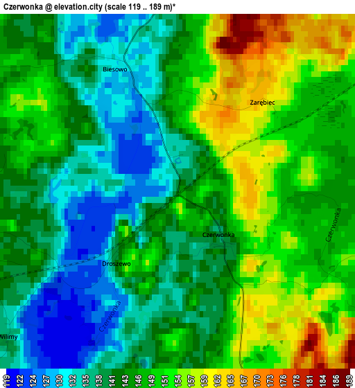
Below is the Elevation map of Czerwonka, which displays elevation range with different colors. Scale of the first map is from 119 to 189 m (390 to 620 ft) with average elevation of 144.8 meters (=475 ft) [note 1]
These maps also provides idea of topography and contour of this city, they are displayed at different zoom levels. More info about maps, scale and edge coordinates you can find below images.
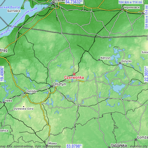
| \ | Map #1 | Topo.Map |
| Scale [m] | 119..189 m | × |
| Scale [ft] | 390..620 ft | × |
| Average | 144.8 m = 475 ft | × |
| Width | 5.76 km = 3.6 mi | 184.2 km = 114.5 mi |
| Height | 5.76 km = 3.6 mi | 184.2 km = 114.5 mi |
| ↑Max Latitude | 53.942144° | 54.73632° |
| Latitude at center | 53.91627° | 53.91627° |
| ↓Min Latitude | 53.89038° | 53.0798° |
| ← Min Longitude | 20.852905° | 19.4906° |
| Longitude center | 20.89685° | 20.89685° |
| →Max Longitude | 20.940795° | 22.3031° |
Nearby cities:
Cities around Czerwonka sort by population:
• Olsztyn elevation 139 m
30.5 km,  240°
240°
• Mrągowo 138 m
27.4 km,  102°
102°
• Lidzbark Warmiński 71 m
31.2 km,  318°
318°
• Biskupiec 152 m
7 km,  145°
145°
• Barczewo 129 m
16.5 km,  234°
234°
• Reszel 110 m
22.1 km,  47°
47°
• Jeziorany 142 m
11.9 km,  303°
303°
• Pasym 142 m
30.3 km,  193°
193°
• Bisztynek 128 m
18.9 km,  1°
1°
• Dywity 132 m
28.8 km,  252°
252°
• Dźwierzuty 146 m
23.9 km,  169°
169°
• Purda 141 m
26.3 km,  208°
208°
Multilingual:
 En español:
Czerwonka elevación 144 m.
 En France:
Czerwonka élévation 144 m.
 Auf Deutsch:
Czerwonka höhe über dem Meeresspiegel ist 144 m.

Sources and notes:
- [note 1] Map square and city borders are not equal. Map elevation data is calculated only from area inside that square.
- [src 1] Elevation data from geonames database provided with same terms of usage.
- [src 2] The elevation map of Czerwonka is generated using elevation data from NASA's 3 arcsec (90m) resolution SRTM data.
- [src 3] Base (background) map © OpenStreetMap contributors tiles are generated by Geofabrik and OpenTopoMap.
Copyright & License:
This Czerwonka Elevation Map is licensed under CC BY-SA. You may reuse any part from this page, if you give a proper credit by linking to this URL:
 More info on terms of use page.