Kozłowo elevation
Kozłowo (Warmia-Masuria, Powiat nidzicki), Poland elevation is 179 meters and Kozłowo elevation in feet is 587 ft above sea level [src 1]. Kozłowo is a populated place (feature code) with elevation that is 12 meters (39 ft) smaller than average city elevation in Poland.
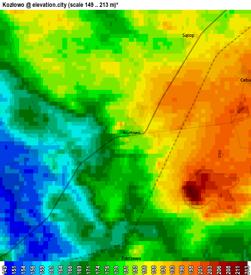
Below is the Elevation map of Kozłowo, which displays elevation range with different colors. Scale of the first map is from 149 to 213 m (489 to 699 ft) with average elevation of 178.4 meters (=585 ft) [note 1]
These maps also provides idea of topography and contour of this city, they are displayed at different zoom levels. More info about maps, scale and edge coordinates you can find below images.
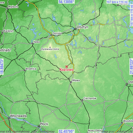
| \ | Map #1 | Topo.Map |
| Scale [m] | 149..213 m | × |
| Scale [ft] | 489..699 ft | × |
| Average | 178.4 m = 585 ft | × |
| Width | 5.84 km = 3.6 mi | 186.9 km = 116.1 mi |
| Height | 5.84 km = 3.6 mi | 186.8 km = 116.1 mi |
| ↑Max Latitude | 53.332771° | 54.13856° |
| Latitude at center | 53.30652° | 53.30652° |
| ↓Min Latitude | 53.280253° | 52.45795° |
| ← Min Longitude | 20.247035° | 18.88473° |
| Longitude center | 20.29098° | 20.29098° |
| →Max Longitude | 20.334925° | 21.69723° |
Nearby cities:
Cities around Kozłowo sort by population:
• Mława elevation 149 m
22.4 km,  163°
163°
• Działdowo 161 m
11 km,  227°
227°
• Nidzica 175 m
10.9 km,  56°
56°
• Iłowo -Osada 158 m
15.4 km,  179°
179°
• Rybno 154 m
25.3 km,  289°
289°
• Dąbrówno 170 m
22.1 km,  309°
309°
• Lipowiec Kościelny 135 m
23.7 km,  198°
198°
• Gierzwałd 193 m
29.3 km,  332°
332°
• Szydłowo 146 m
27.3 km, 157°
• Wiśniewo 139 m
27.2 km,  171°
171°
• Wieczfnia Kościelna 157 m
17.5 km,  135°
135°
• Kuczbork-Osada 128 m
29.4 km,  213°
213°
Multilingual:
 En español:
Kozłowo elevación 179 m.
 En France:
Kozłowo élévation 179 m.


Sources and notes:
- [note 1] Map square and city borders are not equal. Map elevation data is calculated only from area inside that square.
- [src 1] Elevation data from geonames database provided with same terms of usage.
- [src 2] The elevation map of Kozłowo is generated using elevation data from NASA's 3 arcsec (90m) resolution SRTM data.
- [src 3] Base (background) map © OpenStreetMap contributors tiles are generated by Geofabrik and OpenTopoMap.
Copyright & License:
This Kozłowo Elevation Map is licensed under CC BY-SA. You may reuse any part from this page, if you give a proper credit by linking to this URL:
 More info on terms of use page.