Sarnaki elevation
Sarnaki (Mazovia, Powiat łosicki), Poland elevation is 141 meters and Sarnaki elevation in feet is 463 ft above sea level [src 1]. Sarnaki is a populated place (feature code) with elevation that is 50 meters (164 ft) smaller than average city elevation in Poland.
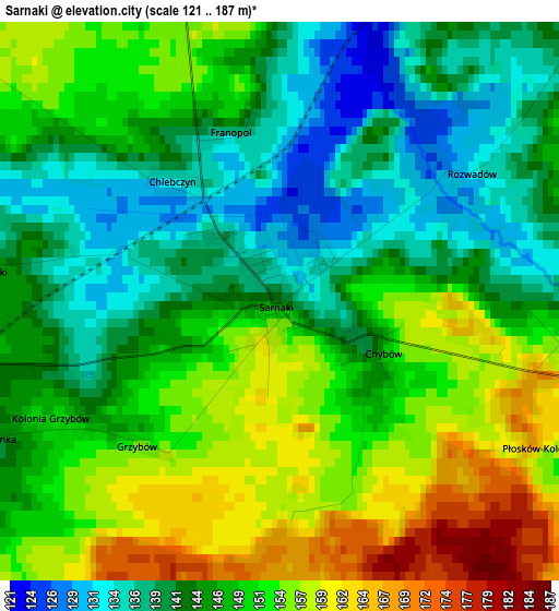
Below is the Elevation map of Sarnaki, which displays elevation range with different colors. Scale of the first map is from 121 to 187 m (397 to 614 ft) with average elevation of 147.5 meters (=484 ft) [note 1]
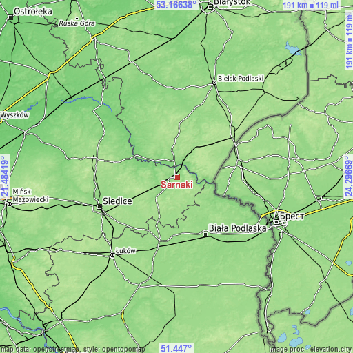
These maps also provides idea of topography and contour of this city, they are displayed at different zoom levels. More info about maps, scale and edge coordinates you can find below images.
| \ | Map #1 | Topo.Map |
| Scale [m] | 121..187 m | × |
| Scale [ft] | 397..614 ft | × |
| Average | 147.5 m = 484 ft | × |
| Width | 5.97 km = 3.7 mi | 191.2 km = 118.8 mi |
| Height | 5.97 km = 3.7 mi | 191.2 km = 118.8 mi |
| ↑Max Latitude | 52.341896° | 53.16638° |
| Latitude at center | 52.31504° | 52.31504° |
| ↓Min Latitude | 52.288167° | 51.447° |
| ← Min Longitude | 22.846495° | 21.48419° |
| Longitude center | 22.89044° | 22.89044° |
| →Max Longitude | 22.934385° | 24.29669° |
Nearby cities:
Cities around Sarnaki sort by population:
• Siemiatycze elevation 147 m
12.6 km,  351°
351°
• Łosice 150 m
16.5 km,  225°
225°
• Janów Podlaski 144 m
25.7 km,  121°
121°
• Drohiczyn 147 m
18.4 km,  300°
300°
• Nurzec-Stacja 182 m
21.1 km,  38°
38°
• Mordy 161 m
27.9 km,  245°
245°
• Konstantynów 153 m
17.9 km,  132°
132°
• Stara Kornica 161 m
15.2 km,  167°
167°
• Leśna Podlaska 146 m
22.3 km,  155°
155°
• Korczew 150 m
19.3 km,  282°
282°
• Przesmyki 172 m
21.5 km,  255°
255°
• Dziadkowice 166 m
27.7 km,  3°
3°
Multilingual:
 En español:
Sarnaki elevación 141 m.
 En France:
Sarnaki élévation 141 m.


Sources and notes:
- [note 1] Map square and city borders are not equal. Map elevation data is calculated only from area inside that square.
- [src 1] Elevation data from geonames database provided with same terms of usage.
- [src 2] The elevation map of Sarnaki is generated using elevation data from NASA's 3 arcsec (90m) resolution SRTM data.
- [src 3] Base (background) map © OpenStreetMap contributors tiles are generated by Geofabrik and OpenTopoMap.
Copyright & License:
This Sarnaki Elevation Map is licensed under CC BY-SA. You may reuse any part from this page, if you give a proper credit by linking to this URL:
 More info on terms of use page.