Dziadkowice elevation
Dziadkowice (Podlasie, Powiat siemiatycki), Poland elevation is 166 meters and Dziadkowice elevation in feet is 545 ft above sea level [src 1]. Dziadkowice is a seat of a third-order administrative division (feature code) with elevation that is 25 meters (82 ft) smaller than average city elevation in Poland.
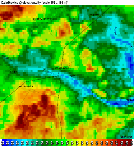
Below is the Elevation map of Dziadkowice, which displays elevation range with different colors. Scale of the first map is from 152 to 191 m (499 to 627 ft) with average elevation of 170 meters (=558 ft) [note 1]
These maps also provides idea of topography and contour of this city, they are displayed at different zoom levels. More info about maps, scale and edge coordinates you can find below images.
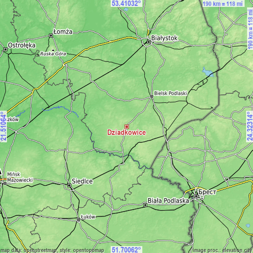
| \ | Map #1 | Topo.Map |
| Scale [m] | 152..191 m | × |
| Scale [ft] | 499..627 ft | × |
| Average | 170 m = 558 ft | × |
| Width | 5.94 km = 3.7 mi | 190.1 km = 118.1 mi |
| Height | 5.94 km = 3.7 mi | 190.1 km = 118.1 mi |
| ↑Max Latitude | 52.590505° | 53.41032° |
| Latitude at center | 52.5638° | 52.5638° |
| ↓Min Latitude | 52.537078° | 51.70062° |
| ← Min Longitude | 22.872945° | 21.51064° |
| Longitude center | 22.91689° | 22.91689° |
| →Max Longitude | 22.960835° | 24.32314° |
Nearby cities:
Cities around Dziadkowice sort by population:
• Bielsk Podlaski elevation 139 m
28.8 km,  39°
39°
• Siemiatycze 147 m
15.6 km,  193°
193°
• Brańsk 130 m
20.8 km,  345°
345°
• Czeremcha 176 m
29.8 km,  100°
100°
• Drohiczyn 147 m
25.2 km,  223°
223°
• Nurzec-Stacja 182 m
16 km,  134°
134°
• Boćki 145 m
13 km, 41°
• Kleszczele 163 m
27.6 km,  87°
87°
• Rudka 136 m
22 km,  324°
324°
• Sarnaki 141 m
27.7 km,  183°
183°
• Milejczyce 163 m
15.4 km,  108°
108°
• Perlejewo 126 m
23.8 km,  270°
270°
Multilingual:
 En español:
Dziadkowice elevación 166 m.
 En France:
Dziadkowice élévation 166 m.
 Auf Deutsch:
Dziadkowice höhe über dem Meeresspiegel ist 166 m.

Sources and notes:
- [note 1] Map square and city borders are not equal. Map elevation data is calculated only from area inside that square.
- [src 1] Elevation data from geonames database provided with same terms of usage.
- [src 2] The elevation map of Dziadkowice is generated using elevation data from NASA's 3 arcsec (90m) resolution SRTM data.
- [src 3] Base (background) map © OpenStreetMap contributors tiles are generated by Geofabrik and OpenTopoMap.
Copyright & License:
This Dziadkowice Elevation Map is licensed under CC BY-SA. You may reuse any part from this page, if you give a proper credit by linking to this URL:
 More info on terms of use page.