Przesmyki elevation
Przesmyki (Mazovia, Powiat siedlecki), Poland elevation is 172 meters and Przesmyki elevation in feet is 564 ft above sea level [src 1]. Przesmyki is a seat of a third-order administrative division (feature code) with elevation that is 19 meters (62 ft) smaller than average city elevation in Poland.
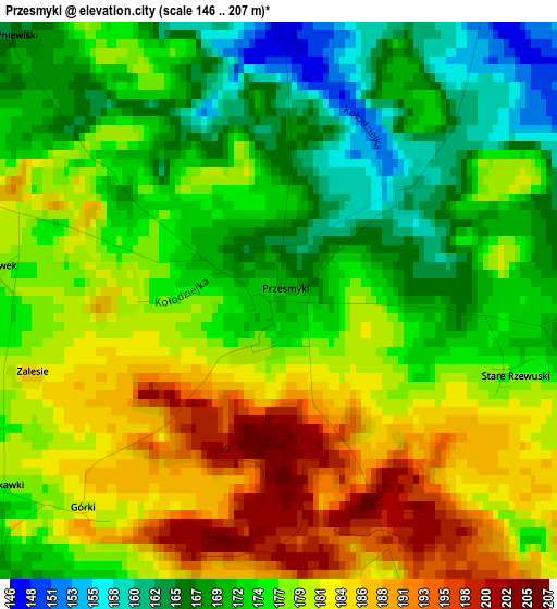
Below is the Elevation map of Przesmyki, which displays elevation range with different colors. Scale of the first map is from 146 to 207 m (479 to 679 ft) with average elevation of 176.5 meters (=579 ft) [note 1]
These maps also provides idea of topography and contour of this city, they are displayed at different zoom levels. More info about maps, scale and edge coordinates you can find below images.
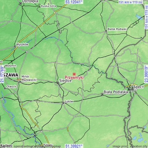
| \ | Map #1 | Topo.Map |
| Scale [m] | 146..207 m | × |
| Scale [ft] | 479..679 ft | × |
| Average | 176.5 m = 579 ft | × |
| Width | 5.98 km = 3.7 mi | 191.4 km = 118.9 mi |
| Height | 5.98 km = 3.7 mi | 191.4 km = 118.9 mi |
| ↑Max Latitude | 52.295045° | 53.12041° |
| Latitude at center | 52.26816° | 52.26816° |
| ↓Min Latitude | 52.241259° | 51.39921° |
| ← Min Longitude | 22.539995° | 21.17769° |
| Longitude center | 22.58394° | 22.58394° |
| →Max Longitude | 22.627885° | 23.99019° |
Nearby cities:
Cities around Przesmyki sort by population:
• Siedlce elevation 150 m
22.9 km,  240°
240°
• Łosice 150 m
11.1 km,  124°
124°
• Drohiczyn 147 m
15.5 km,  19°
19°
• Mordy 161 m
7.8 km,  215°
215°
• Zbuczyn 159 m
22.2 km,  206°
206°
• Jabłonna Lacka 134 m
25.1 km,  337°
337°
• Sarnaki 141 m
21.5 km,  75°
75°
• Repki 170 m
18.5 km,  314°
314°
• Korczew 150 m
9.7 km,  11°
11°
• Suchożebry 148 m
22.5 km,  267°
267°
• Paprotnia 177 m
8.7 km,  294°
294°
• Bielany 158 m
24.2 km, 289°
Multilingual:
 En español:
Przesmyki elevación 172 m.
 En France:
Przesmyki élévation 172 m.
 Auf Deutsch:
Przesmyki höhe über dem Meeresspiegel ist 172 m.

Sources and notes:
- [note 1] Map square and city borders are not equal. Map elevation data is calculated only from area inside that square.
- [src 1] Elevation data from geonames database provided with same terms of usage.
- [src 2] The elevation map of Przesmyki is generated using elevation data from NASA's 3 arcsec (90m) resolution SRTM data.
- [src 3] Base (background) map © OpenStreetMap contributors tiles are generated by Geofabrik and OpenTopoMap.
Copyright & License:
This Przesmyki Elevation Map is licensed under CC BY-SA. You may reuse any part from this page, if you give a proper credit by linking to this URL:
 More info on terms of use page.