Wieliszew elevation
Wieliszew (Mazovia, Powiat legionowski), Poland elevation is 75 meters and Wieliszew elevation in feet is 246 ft above sea level [src 1]. Wieliszew is a seat of a third-order administrative division (feature code) with elevation that is 116 meters (381 ft) smaller than average city elevation in Poland.
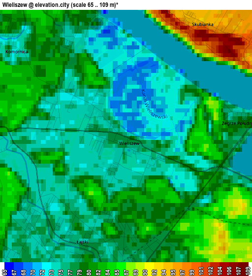
Below is the Elevation map of Wieliszew, which displays elevation range with different colors. Scale of the first map is from 65 to 109 m (213 to 358 ft) with average elevation of 78.8 meters (=259 ft) [note 1]
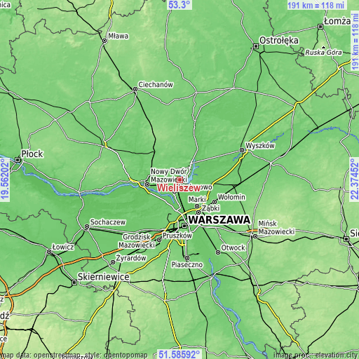
These maps also provides idea of topography and contour of this city, they are displayed at different zoom levels. More info about maps, scale and edge coordinates you can find below images.
| \ | Map #1 | Topo.Map |
| Scale [m] | 65..109 m | × |
| Scale [ft] | 213..358 ft | × |
| Average | 78.8 m = 259 ft | × |
| Width | 5.96 km = 3.7 mi | 190.6 km = 118.4 mi |
| Height | 5.96 km = 3.7 mi | 190.6 km = 118.4 mi |
| ↑Max Latitude | 52.478074° | 53.3° |
| Latitude at center | 52.4513° | 52.4513° |
| ↓Min Latitude | 52.42451° | 51.58592° |
| ← Min Longitude | 20.924325° | 19.56202° |
| Longitude center | 20.96827° | 20.96827° |
| →Max Longitude | 21.012215° | 22.37452° |
Nearby cities:
Cities around Wieliszew sort by population:
• Białołeka elevation 80 m
14.5 km,  178°
178°
• Legionowo 77 m
6.2 km,  207°
207°
• Łomianki 77 m
14.2 km,  203°
203°
• Jabłonna 76 m
8.8 km, 203°
• Serock 112 m
9.5 km,  46°
46°
• Nieporęt 76 m
4.9 km,  116°
116°
• Dziekanów Leśny 75 m
13.6 km,  215°
215°
• Kiełpin 75 m
12.6 km, 214°
• Michałów-Reginów 77 m
3.8 km, 182°
• Łajski 76 m
2.8 km, 206°
• Białobrzegi 84 m
5.8 km,  100°
100°
• Stanisławów Pierwszy 79 m
10.2 km,  146°
146°
Multilingual:
 En español:
Wieliszew elevación 75 m.
 En France:
Wieliszew élévation 75 m.
 Auf Deutsch:
Wieliszew höhe über dem Meeresspiegel ist 75 m.

Sources and notes:
- [note 1] Map square and city borders are not equal. Map elevation data is calculated only from area inside that square.
- [src 1] Elevation data from geonames database provided with same terms of usage.
- [src 2] The elevation map of Wieliszew is generated using elevation data from NASA's 3 arcsec (90m) resolution SRTM data.
- [src 3] Base (background) map © OpenStreetMap contributors tiles are generated by Geofabrik and OpenTopoMap.
Copyright & License:
This Wieliszew Elevation Map is licensed under CC BY-SA. You may reuse any part from this page, if you give a proper credit by linking to this URL:
 More info on terms of use page.