Kiełpin elevation
Kiełpin (Mazovia, Powiat warszawski zachodni), Poland elevation is 75 meters and Kiełpin elevation in feet is 246 ft above sea level [src 1]. Kiełpin is a populated place (feature code) with elevation that is 116 meters (381 ft) smaller than average city elevation in Poland.
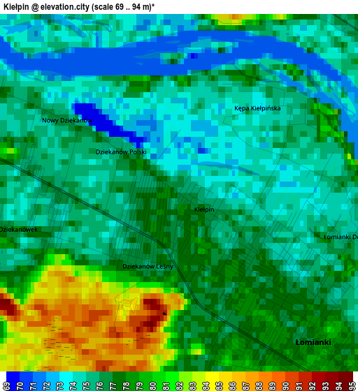
Below is the Elevation map of Kiełpin, which displays elevation range with different colors. Scale of the first map is from 69 to 94 m (226 to 308 ft) with average elevation of 76.3 meters (=250 ft) [note 1]
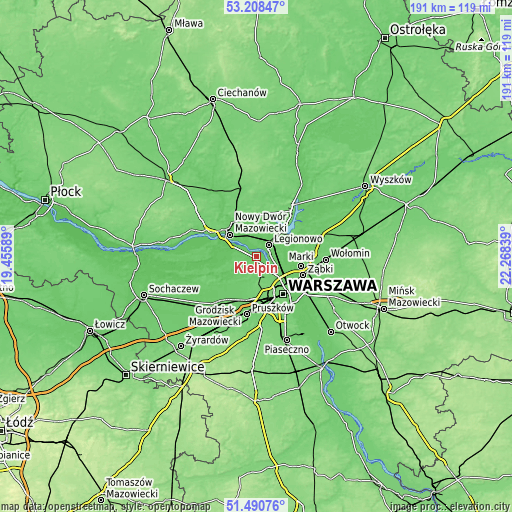
These maps also provides idea of topography and contour of this city, they are displayed at different zoom levels. More info about maps, scale and edge coordinates you can find below images.
| \ | Map #1 | Topo.Map |
| Scale [m] | 69..94 m | × |
| Scale [ft] | 226..308 ft | × |
| Average | 76.3 m = 250 ft | × |
| Width | 5.97 km = 3.7 mi | 191 km = 118.7 mi |
| Height | 5.97 km = 3.7 mi | 191 km = 118.7 mi |
| ↑Max Latitude | 52.38479° | 53.20847° |
| Latitude at center | 52.35796° | 52.35796° |
| ↓Min Latitude | 52.331113° | 51.49076° |
| ← Min Longitude | 20.818195° | 19.45589° |
| Longitude center | 20.86214° | 20.86214° |
| →Max Longitude | 20.906085° | 22.26839° |
Nearby cities:
Cities around Kiełpin sort by population:
• Bielany elevation 98 m
8.8 km,  145°
145°
• Białołeka 80 m
8.5 km,  118°
118°
• Legionowo 77 m
6.5 km,  42°
42°
• Łomianki 77 m
3.1 km, 148°
• Jabłonna 76 m
4.4 km,  58°
58°
• Izabelin 84 m
7.1 km,  205°
205°
• Dziekanów Leśny 75 m
1 km,  230°
230°
• Truskaw 80 m
8.3 km,  220°
220°
• Michałów-Reginów 77 m
9.6 km,  46°
46°
• Łajski 76 m
9.9 km, 36°
• Stare Babice 97 m
11 km,  189°
189°
• Hornówek 90 m
8.8 km,  204°
204°
Multilingual:
 En español:
Kiełpin elevación 75 m.
 En France:
Kiełpin élévation 75 m.


Sources and notes:
- [note 1] Map square and city borders are not equal. Map elevation data is calculated only from area inside that square.
- [src 1] Elevation data from geonames database provided with same terms of usage.
- [src 2] The elevation map of Kiełpin is generated using elevation data from NASA's 3 arcsec (90m) resolution SRTM data.
- [src 3] Base (background) map © OpenStreetMap contributors tiles are generated by Geofabrik and OpenTopoMap.
Copyright & License:
This Kiełpin Elevation Map is licensed under CC BY-SA. You may reuse any part from this page, if you give a proper credit by linking to this URL:
 More info on terms of use page.