Nieporęt elevation
Nieporęt (Mazovia, Powiat legionowski), Poland elevation is 76 meters and Nieporęt elevation in feet is 249 ft above sea level [src 1]. Nieporęt is a seat of a third-order administrative division (feature code) with elevation that is 115 meters (377 ft) smaller than average city elevation in Poland.
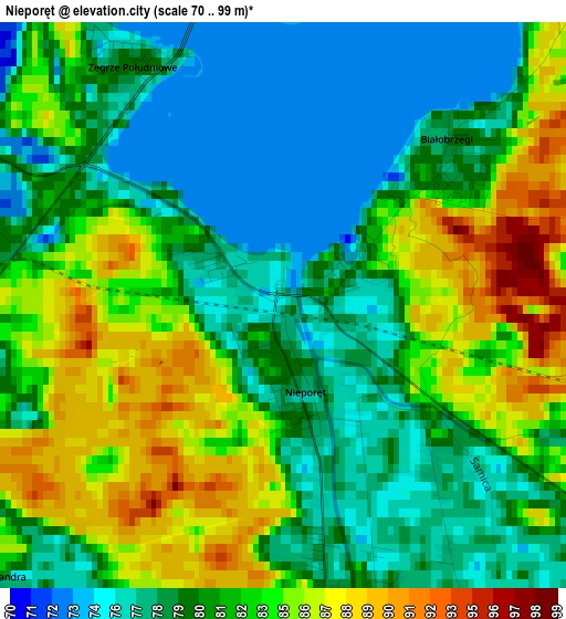
Below is the Elevation map of Nieporęt, which displays elevation range with different colors. Scale of the first map is from 70 to 99 m (230 to 325 ft) with average elevation of 81.3 meters (=267 ft) [note 1]
These maps also provides idea of topography and contour of this city, they are displayed at different zoom levels. More info about maps, scale and edge coordinates you can find below images.
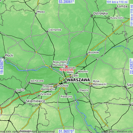
| \ | Map #1 | Topo.Map |
| Scale [m] | 70..99 m | × |
| Scale [ft] | 230..325 ft | × |
| Average | 81.3 m = 267 ft | × |
| Width | 5.96 km = 3.7 mi | 190.7 km = 118.5 mi |
| Height | 5.96 km = 3.7 mi | 190.7 km = 118.5 mi |
| ↑Max Latitude | 52.458306° | 53.28061° |
| Latitude at center | 52.43152° | 52.43152° |
| ↓Min Latitude | 52.404718° | 51.56575° |
| ← Min Longitude | 20.988175° | 19.62587° |
| Longitude center | 21.03212° | 21.03212° |
| →Max Longitude | 21.076065° | 22.43837° |
Nearby cities:
Cities around Nieporęt sort by population:
• Białołeka elevation 80 m
12.9 km,  198°
198°
• Legionowo 77 m
7.9 km,  244°
244°
• Marki 87 m
13.3 km,  158°
158°
• Radzymin 90 m
10.5 km,  99°
99°
• Jabłonna 76 m
9.7 km,  233°
233°
• Serock 112 m
9.1 km,  15°
15°
• Wieliszew 75 m
4.9 km,  296°
296°
• Słupno 88 m
9.9 km,  122°
122°
• Michałów-Reginów 77 m
4.8 km,  250°
250°
• Łajski 76 m
5.6 km,  266°
266°
• Białobrzegi 84 m
1.8 km,  49°
49°
• Stanisławów Pierwszy 79 m
6.4 km,  168°
168°
Multilingual:
 En español:
Nieporęt elevación 76 m.
 En France:
Nieporęt élévation 76 m.


Sources and notes:
- [note 1] Map square and city borders are not equal. Map elevation data is calculated only from area inside that square.
- [src 1] Elevation data from geonames database provided with same terms of usage.
- [src 2] The elevation map of Nieporęt is generated using elevation data from NASA's 3 arcsec (90m) resolution SRTM data.
- [src 3] Base (background) map © OpenStreetMap contributors tiles are generated by Geofabrik and OpenTopoMap.
Copyright & License:
This Nieporęt Elevation Map is licensed under CC BY-SA. You may reuse any part from this page, if you give a proper credit by linking to this URL:
 More info on terms of use page.