Bełchatów elevation
Bełchatów (Łódź Voivodeship, Powiat bełchatowski), Poland elevation is 202 meters and Bełchatów elevation in feet is 663 ft above sea level [src 1]. Bełchatów is a seat of a second-order administrative division (feature code) with elevation that is 11 meters (36 ft) bigger than average city elevation in Poland.
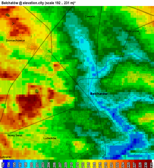
Below is the Elevation map of Bełchatów, which displays elevation range with different colors. Scale of the first map is from 192 to 231 m (630 to 758 ft) with average elevation of 209 meters (=686 ft) [note 1]
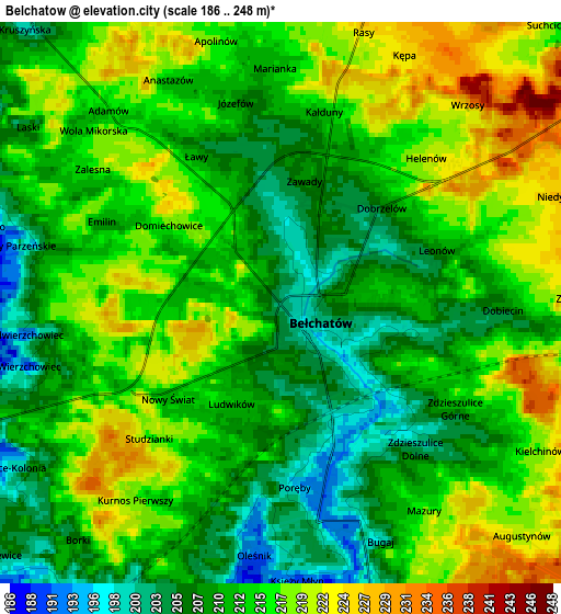
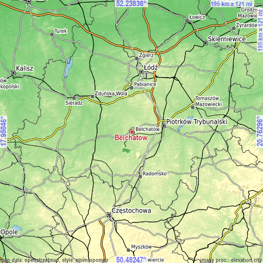
These maps also provides idea of topography and contour of this city, they are displayed at different zoom levels. More info about maps, scale and edge coordinates you can find below images.
| \ | Map #1 | Map #2 | Topo.Map |
| Scale [m] | 192..231 m | 186..248 m | × |
| Scale [ft] | 630..758 ft | 610..814 ft | × |
| Average | 209 m = 686 ft | 213 m = 699 ft | × |
| Width | 6.1 km = 3.8 mi | 12.2 km = 7.6 mi | 195.2 km = 121.3 mi |
| Height | 6.1 km = 3.8 mi | 12.2 km = 7.6 mi | 195.2 km = 121.3 mi |
| ↑Max Latitude | 51.396257° | 51.423668° | 52.23836° |
| Latitude at center | 51.36883° | 51.36883° | 51.36883° |
| ↓Min Latitude | 51.341387° | 51.313927° | 50.48247° |
| ← Min Longitude | 19.312765° | 19.268819° | 17.95046° |
| Longitude center | 19.35671° | 19.35671° | 19.35671° |
| →Max Longitude | 19.400655° | 19.444601° | 20.76296° |
Nearby cities:
Cities around Bełchatów sort by population:
• Zelów elevation 189 m
14.3 km,  318°
318°
• Szczerców 167 m
17.6 km,  256°
256°
• Kamieńsk 224 m
20.9 km,  152°
152°
• Wola Krzysztoporska 204 m
15.8 km,  99°
99°
• Kleszczów 204 m
16.6 km,  192°
192°
• Rozprza 194 m
21.4 km,  110°
110°
• Sulmierzyce 223 m
23.3 km,  208°
208°
• Dłutów 212 m
21.3 km,  6°
6°
• Buczek 187 m
20 km, 318°
• Kluki 192 m
8.7 km,  249°
249°
• Drużbice 198 m
10.9 km, 13°
• Grabica 222 m
17.3 km,  44°
44°
Multilingual:
 En español:
Bełchatów elevación 202 m.
 En France:
Bełchatów élévation 202 m.
 Auf Deutsch:
Bełchatów höhe über dem Meeresspiegel ist 202 m.

Sources and notes:
- [note 1] Map square and city borders are not equal. Map elevation data is calculated only from area inside that square.
- [src 1] Elevation data from geonames database provided with same terms of usage.
- [src 2] The elevation map of Bełchatów is generated using elevation data from NASA's 3 arcsec (90m) resolution SRTM data.
- [src 3] Base (background) map © OpenStreetMap contributors tiles are generated by Geofabrik and OpenTopoMap.
Copyright & License:
This Bełchatów Elevation Map is licensed under CC BY-SA. You may reuse any part from this page, if you give a proper credit by linking to this URL:
 More info on terms of use page.