Dłutów elevation
Dłutów (Łódź Voivodeship, Powiat pabianicki), Poland elevation is 212 meters and Dłutów elevation in feet is 696 ft above sea level [src 1]. Dłutów is a seat of a third-order administrative division (feature code) with elevation that is 21 meters (69 ft) bigger than average city elevation in Poland.
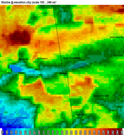
Below is the Elevation map of Dłutów, which displays elevation range with different colors. Scale of the first map is from 193 to 246 m (633 to 807 ft) with average elevation of 219.3 meters (=719 ft) [note 1]
These maps also provides idea of topography and contour of this city, they are displayed at different zoom levels. More info about maps, scale and edge coordinates you can find below images.
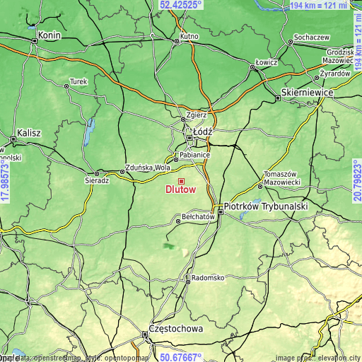
| \ | Map #1 | Topo.Map |
| Scale [m] | 193..246 m | × |
| Scale [ft] | 633..807 ft | × |
| Average | 219.3 m = 719 ft | × |
| Width | 6.08 km = 3.8 mi | 194.4 km = 120.8 mi |
| Height | 6.08 km = 3.8 mi | 194.4 km = 120.8 mi |
| ↑Max Latitude | 51.586673° | 52.42525° |
| Latitude at center | 51.55936° | 51.55936° |
| ↓Min Latitude | 51.532031° | 50.67667° |
| ← Min Longitude | 19.348035° | 17.98573° |
| Longitude center | 19.39198° | 19.39198° |
| →Max Longitude | 19.435925° | 20.79823° |
Nearby cities:
Cities around Dłutów sort by population:
• Pabianice elevation 179 m
12 km,  347°
347°
• Łask 171 m
18.2 km,  280°
280°
• Zelów 189 m
15.9 km,  228°
228°
• Tuszyn 209 m
11.1 km,  59°
59°
• Ksawerów 184 m
13.8 km,  3°
3°
• Rzgów 188 m
13.5 km,  30°
30°
• Czarnocin 207 m
20.3 km,  79°
79°
• Starowa Góra 188 m
16 km,  23°
23°
• Dobroń 182 m
13.4 km,  311°
311°
• Buczek 187 m
17 km,  248°
248°
• Drużbice 198 m
10.6 km,  179°
179°
• Grabica 222 m
13.1 km,  132°
132°
Multilingual:
 En español:
Dłutów elevación 212 m.
 En France:
Dłutów élévation 212 m.


Sources and notes:
- [note 1] Map square and city borders are not equal. Map elevation data is calculated only from area inside that square.
- [src 1] Elevation data from geonames database provided with same terms of usage.
- [src 2] The elevation map of Dłutów is generated using elevation data from NASA's 3 arcsec (90m) resolution SRTM data.
- [src 3] Base (background) map © OpenStreetMap contributors tiles are generated by Geofabrik and OpenTopoMap.
Copyright & License:
This Dłutów Elevation Map is licensed under CC BY-SA. You may reuse any part from this page, if you give a proper credit by linking to this URL:
 More info on terms of use page.