Starowa Góra elevation
Starowa Góra (Łódź Voivodeship, Powiat łódzki wschodni), Poland elevation is 188 meters and Starowa Góra elevation in feet is 617 ft above sea level [src 1]. Starowa Góra is a populated place (feature code) with elevation that is 3 meters (10 ft) smaller than average city elevation in Poland.
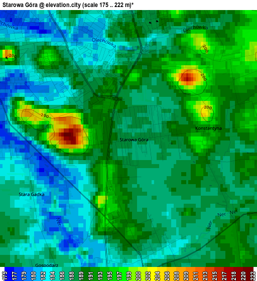
Below is the Elevation map of Starowa Góra, which displays elevation range with different colors. Scale of the first map is from 175 to 222 m (574 to 728 ft) with average elevation of 188.5 meters (=618 ft) [note 1]
These maps also provides idea of topography and contour of this city, they are displayed at different zoom levels. More info about maps, scale and edge coordinates you can find below images.
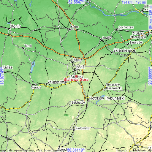
| \ | Map #1 | Topo.Map |
| Scale [m] | 175..222 m | × |
| Scale [ft] | 574..728 ft | × |
| Average | 188.5 m = 618 ft | × |
| Width | 6.06 km = 3.8 mi | 193.9 km = 120.5 mi |
| Height | 6.06 km = 3.8 mi | 193.8 km = 120.4 mi |
| ↑Max Latitude | 51.718573° | 52.5547° |
| Latitude at center | 51.69134° | 51.69134° |
| ↓Min Latitude | 51.66409° | 50.81119° |
| ← Min Longitude | 19.439795° | 18.07749° |
| Longitude center | 19.48374° | 19.48374° |
| →Max Longitude | 19.527685° | 20.88999° |
Nearby cities:
Cities around Starowa Góra sort by population:
• Łódź elevation 223 m
8.8 km,  355°
355°
• Pabianice 179 m
9.4 km,  251°
251°
• Konstantynów Łódzki 167 m
12.6 km,  299°
299°
• Tuszyn 209 m
9.6 km,  160°
160°
• Ksawerów 184 m
5.7 km,  260°
260°
• Andrespol 213 m
11.6 km,  69°
69°
• Rzgów 188 m
3.2 km,  169°
169°
• Gałków Mały 218 m
16.3 km,  76°
76°
• Czarnocin 207 m
17.6 km,  129°
129°
• Dobroń 182 m
17.4 km, 250°
• Dłutów 212 m
16 km,  203°
203°
• Brójce 202 m
11.7 km,  104°
104°
Multilingual:
 En español:
Starowa Góra elevación 188 m.
 En France:
Starowa Góra élévation 188 m.
 Auf Deutsch:
Starowa Góra höhe über dem Meeresspiegel ist 188 m.

Sources and notes:
- [note 1] Map square and city borders are not equal. Map elevation data is calculated only from area inside that square.
- [src 1] Elevation data from geonames database provided with same terms of usage.
- [src 2] The elevation map of Starowa Góra is generated using elevation data from NASA's 3 arcsec (90m) resolution SRTM data.
- [src 3] Base (background) map © OpenStreetMap contributors tiles are generated by Geofabrik and OpenTopoMap.
Copyright & License:
This Starowa Góra Elevation Map is licensed under CC BY-SA. You may reuse any part from this page, if you give a proper credit by linking to this URL:
 More info on terms of use page.