Bojadła elevation
Bojadła (Lubusz, Powiat zielonogórski), Poland elevation is 58 meters and Bojadła elevation in feet is 190 ft above sea level [src 1]. Bojadła is a seat of a third-order administrative division (feature code) with elevation that is 133 meters (436 ft) smaller than average city elevation in Poland.
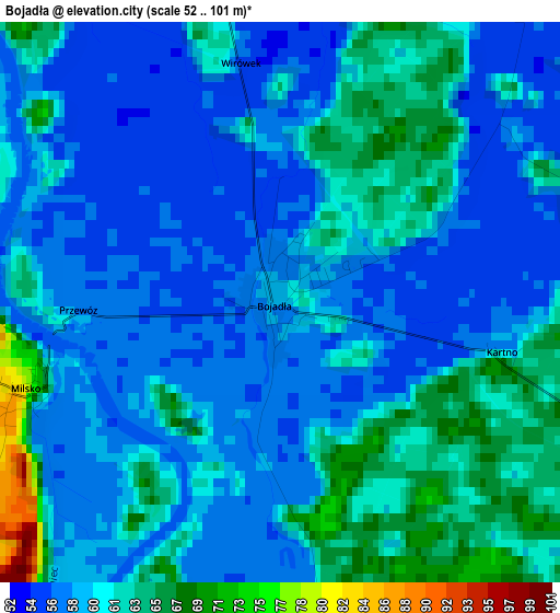
Below is the Elevation map of Bojadła, which displays elevation range with different colors. Scale of the first map is from 52 to 101 m (171 to 331 ft) with average elevation of 59.5 meters (=195 ft) [note 1]
These maps also provides idea of topography and contour of this city, they are displayed at different zoom levels. More info about maps, scale and edge coordinates you can find below images.
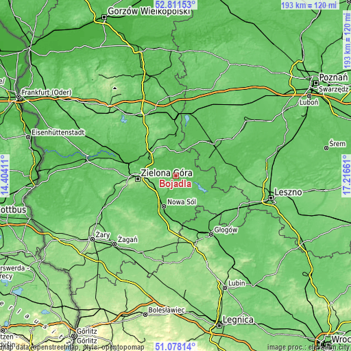
| \ | Map #1 | Topo.Map |
| Scale [m] | 52..101 m | × |
| Scale [ft] | 171..331 ft | × |
| Average | 59.5 m = 195 ft | × |
| Width | 6.02 km = 3.7 mi | 192.7 km = 119.7 mi |
| Height | 6.02 km = 3.7 mi | 192.7 km = 119.7 mi |
| ↑Max Latitude | 51.980286° | 52.81153° |
| Latitude at center | 51.95321° | 51.95321° |
| ↓Min Latitude | 51.926118° | 51.07814° |
| ← Min Longitude | 15.766415° | 14.40411° |
| Longitude center | 15.81036° | 15.81036° |
| →Max Longitude | 15.854305° | 17.21661° |
Nearby cities:
Cities around Bojadła sort by population:
• Nowa Sól elevation 66 m
17.9 km,  201°
201°
• Sulechów 85 m
19.3 km,  318°
318°
• Sława 59 m
19.9 km,  115°
115°
• Kargowa 59 m
13.6 km,  14°
14°
• Siedlisko 86 m
20.5 km,  179°
179°
• Konotop 59 m
6.8 km,  110°
110°
• Klenica 56 m
4.7 km,  337°
337°
• Przyborów 63 m
17.3 km,  189°
189°
• Otyń 64 m
13.6 km,  210°
210°
• Kolsko 56 m
10.3 km,  84°
84°
• Zabór 63 m
6.4 km,  268°
268°
• Trzebiechów 54 m
9.1 km,  326°
326°
Multilingual:
 En español:
Bojadła elevación 58 m.
 En France:
Bojadła élévation 58 m.


Sources and notes:
- [note 1] Map square and city borders are not equal. Map elevation data is calculated only from area inside that square.
- [src 1] Elevation data from geonames database provided with same terms of usage.
- [src 2] The elevation map of Bojadła is generated using elevation data from NASA's 3 arcsec (90m) resolution SRTM data.
- [src 3] Base (background) map © OpenStreetMap contributors tiles are generated by Geofabrik and OpenTopoMap.
Copyright & License:
This Bojadła Elevation Map is licensed under CC BY-SA. You may reuse any part from this page, if you give a proper credit by linking to this URL:
 More info on terms of use page.