Siedlisko elevation
Siedlisko (Lubusz, Powiat nowosolski), Poland elevation is 86 meters and Siedlisko elevation in feet is 282 ft above sea level [src 1]. Siedlisko is a seat of a third-order administrative division (feature code) with elevation that is 105 meters (344 ft) smaller than average city elevation in Poland.
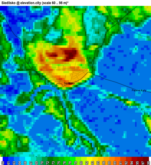
Below is the Elevation map of Siedlisko, which displays elevation range with different colors. Scale of the first map is from 60 to 98 m (197 to 322 ft) with average elevation of 69.4 meters (=228 ft) [note 1]
These maps also provides idea of topography and contour of this city, they are displayed at different zoom levels. More info about maps, scale and edge coordinates you can find below images.
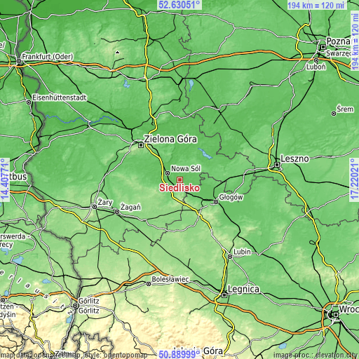
| \ | Map #1 | Topo.Map |
| Scale [m] | 60..98 m | × |
| Scale [ft] | 197..322 ft | × |
| Average | 69.4 m = 228 ft | × |
| Width | 6.05 km = 3.8 mi | 193.5 km = 120.2 mi |
| Height | 6.05 km = 3.8 mi | 193.5 km = 120.2 mi |
| ↑Max Latitude | 51.795827° | 52.63051° |
| Latitude at center | 51.76864° | 51.76864° |
| ↓Min Latitude | 51.741437° | 50.88999° |
| ← Min Longitude | 15.770015° | 14.40771° |
| Longitude center | 15.81396° | 15.81396° |
| →Max Longitude | 15.857905° | 17.22021° |
Nearby cities:
Cities around Siedlisko sort by population:
• Nowa Sól elevation 66 m
7.7 km,  300°
300°
• Kożuchów 101 m
15.3 km,  260°
260°
• Bytom Odrzański 81 m
4.3 km,  171°
171°
• Sława 59 m
21.4 km,  56°
56°
• Nowe Miasteczko 95 m
10.3 km,  213°
213°
• Gaworzyce 153 m
16.4 km,  163°
163°
• Konotop 59 m
19.1 km,  18°
18°
• Kotla 87 m
15.5 km,  99°
99°
• Bojadła 58 m
20.5 km,  359°
359°
• Otyń 64 m
11.3 km,  321°
321°
• Przyborów 63 m
4.7 km, 318°
• Zabór 63 m
21.4 km,  341°
341°
Multilingual:
 En español:
Siedlisko elevación 86 m.
 En France:
Siedlisko élévation 86 m.
 Auf Deutsch:
Siedlisko höhe über dem Meeresspiegel ist 86 m.

Sources and notes:
- [note 1] Map square and city borders are not equal. Map elevation data is calculated only from area inside that square.
- [src 1] Elevation data from geonames database provided with same terms of usage.
- [src 2] The elevation map of Siedlisko is generated using elevation data from NASA's 3 arcsec (90m) resolution SRTM data.
- [src 3] Base (background) map © OpenStreetMap contributors tiles are generated by Geofabrik and OpenTopoMap.
Copyright & License:
This Siedlisko Elevation Map is licensed under CC BY-SA. You may reuse any part from this page, if you give a proper credit by linking to this URL:
 More info on terms of use page.