Głogów elevation
Głogów (Lower Silesia, Powiat głogowski), Poland elevation is 92 meters and Głogów elevation in feet is 302 ft above sea level [src 1]. Głogów is a populated place (feature code) with elevation that is 99 meters (325 ft) smaller than average city elevation in Poland.
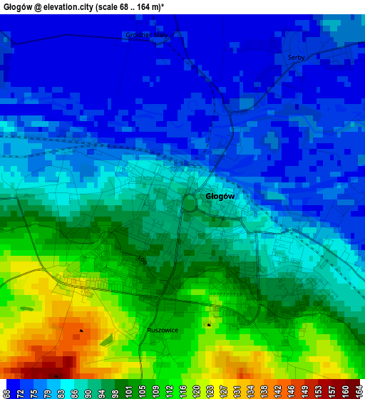
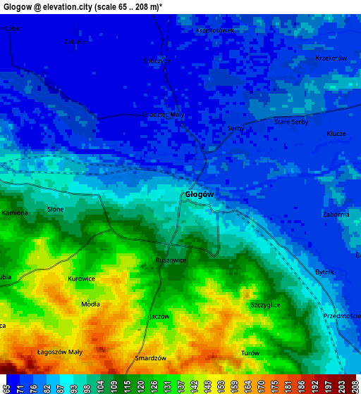
Below is the Elevation map of Głogów, which displays elevation range with different colors. Scale of the first map is from 68 to 164 m (223 to 538 ft) with average elevation of 90.4 meters (=297 ft) [note 1]
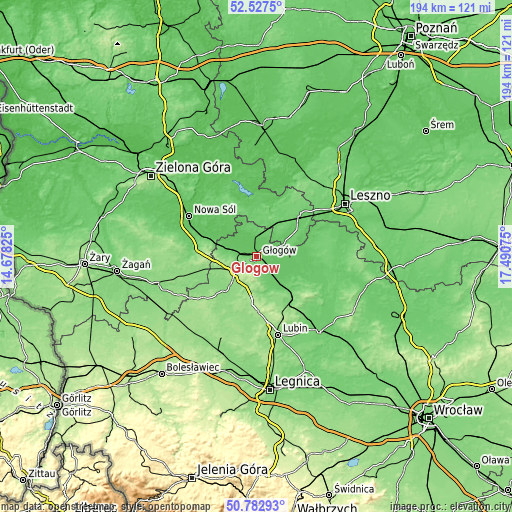
These maps also provides idea of topography and contour of this city, they are displayed at different zoom levels. More info about maps, scale and edge coordinates you can find below images.
| \ | Map #1 | Map #2 | Topo.Map |
| Scale [m] | 68..164 m | 65..208 m | × |
| Scale [ft] | 223..538 ft | 213..682 ft | × |
| Average | 90.4 m = 297 ft | 97.3 m = 319 ft | × |
| Width | 6.06 km = 3.8 mi | 12.12 km = 7.5 mi | 194 km = 120.5 mi |
| Height | 6.06 km = 3.8 mi | 12.12 km = 7.5 mi | 194 km = 120.5 mi |
| ↑Max Latitude | 51.69086° | 51.718094° | 52.5275° |
| Latitude at center | 51.66361° | 51.66361° | 51.66361° |
| ↓Min Latitude | 51.636344° | 51.609061° | 50.78293° |
| ← Min Longitude | 16.040555° | 15.996609° | 14.67825° |
| Longitude center | 16.0845° | 16.0845° | 16.0845° |
| →Max Longitude | 16.128445° | 16.172391° | 17.49075° |
Nearby cities:
Cities around Głogów sort by population:
• Polkowice elevation 179 m
17.8 km,  182°
182°
• Wschowa 100 m
22.6 km,  45°
45°
• Bytom Odrzański 81 m
19.5 km,  292°
292°
• Sława 59 m
23.7 km,  357°
357°
• Nowe Miasteczko 95 m
24.5 km,  277°
277°
• Radwanice 139 m
14 km,  222°
222°
• Siedlisko 86 m
22 km,  302°
302°
• Rudna 115 m
21.1 km,  144°
144°
• Gaworzyce 153 m
14.5 km,  254°
254°
• Grębocice 85 m
9.2 km, 141°
• Kotla 87 m
9.7 km,  339°
339°
• Szlichtyngowa 79 m
12.3 km,  63°
63°
Multilingual:
 En español:
Glogovia elevación 92 m.
 En France:
Głogów élévation 92 m.
 Auf Deutsch:
Glogau, Głogów höhe über dem Meeresspiegel ist 92 m.

Sources and notes:
- [note 1] Map square and city borders are not equal. Map elevation data is calculated only from area inside that square.
- [src 1] Elevation data from geonames database provided with same terms of usage.
- [src 2] The elevation map of Głogów is generated using elevation data from NASA's 3 arcsec (90m) resolution SRTM data.
- [src 3] Base (background) map © OpenStreetMap contributors tiles are generated by Geofabrik and OpenTopoMap.
Copyright & License:
This Głogów Elevation Map is licensed under CC BY-SA. You may reuse any part from this page, if you give a proper credit by linking to this URL:
 More info on terms of use page.