Gorzów Wielkopolski elevation
Gorzów Wielkopolski (Lubusz), Poland elevation is 34 meters and Gorzów Wielkopolski elevation in feet is 112 ft above sea level [src 1]. Gorzów Wielkopolski is a seat of a first-order administrative division (feature code) with elevation that is 157 meters (515 ft) smaller than average city elevation in Poland.
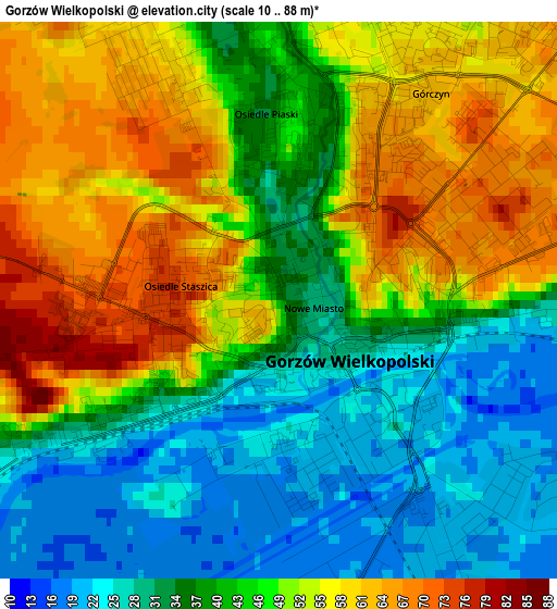
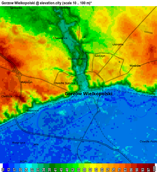
Below is the Elevation map of Gorzów Wielkopolski, which displays elevation range with different colors. Scale of the first map is from 10 to 88 m (33 to 289 ft) with average elevation of 44.1 meters (=145 ft) [note 1]
These maps also provides idea of topography and contour of this city, they are displayed at different zoom levels. More info about maps, scale and edge coordinates you can find below images.
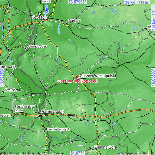
| \ | Map #1 | Map #2 | Topo.Map |
| Scale [m] | 10..88 m | 10..100 m | × |
| Scale [ft] | 33..289 ft | 33..328 ft | × |
| Average | 44.1 m = 145 ft | 44.6 m = 146 ft | × |
| Width | 5.92 km = 3.7 mi | 11.83 km = 7.4 mi | 189.4 km = 117.7 mi |
| Height | 5.92 km = 3.7 mi | 11.83 km = 7.4 mi | 189.3 km = 117.6 mi |
| ↑Max Latitude | 52.76339° | 52.789973° | 53.57995° |
| Latitude at center | 52.73679° | 52.73679° | 52.73679° |
| ↓Min Latitude | 52.710174° | 52.683542° | 51.877° |
| ← Min Longitude | 15.184835° | 15.140889° | 13.82253° |
| Longitude center | 15.22878° | 15.22878° | 15.22878° |
| →Max Longitude | 15.272725° | 15.316671° | 16.63503° |
Nearby cities:
Cities around Gorzów Wielkopolski sort by population:
• Skwierzyna elevation 30 m
24.2 km,  129°
129°
• Witnica 22 m
23.4 km,  252°
252°
• Lubniewice 56 m
24.5 km,  176°
176°
• Kłodawa 51 m
5.5 km,  350°
350°
• Krzeszyce 19 m
22.7 km,  221°
221°
• Zwierzyń 31 m
25.1 km,  65°
65°
• Bogdaniec 24 m
11.9 km,  243°
243°
• Jenin 23 m
9.9 km, 243°
• Deszczno 20 m
9.6 km,  140°
140°
• Lubiszyn 55 m
19.5 km,  284°
284°
• Santok 22 m
12.2 km,  89°
89°
• Nowogródek Pomorski 73 m
23.6 km,  325°
325°
Multilingual:
 En español:
Gorzów Wielkopolski elevación 34 m.
 En France:
Gorzów Wielkopolski élévation 34 m.
 Auf Deutsch:
Landsberg, Landsberg an der Warthe, Gorzów Wielkopolski höhe über dem Meeresspiegel ist 34 m.
 На русском:
Гожув-Велькопольски, Гожув-Велькопольский высота над уровнем моря 34 м
Sources and notes:
- [note 1] Map square and city borders are not equal. Map elevation data is calculated only from area inside that square.
- [src 1] Elevation data from geonames database provided with same terms of usage.
- [src 2] The elevation map of Gorzów Wielkopolski is generated using elevation data from NASA's 3 arcsec (90m) resolution SRTM data.
- [src 3] Base (background) map © OpenStreetMap contributors tiles are generated by Geofabrik and OpenTopoMap.
Copyright & License:
This Gorzów Wielkopolski Elevation Map is licensed under CC BY-SA. You may reuse any part from this page, if you give a proper credit by linking to this URL:
 More info on terms of use page.