Lubniewice elevation
Lubniewice (Lubusz, Powiat sulęciński), Poland elevation is 56 meters and Lubniewice elevation in feet is 184 ft above sea level [src 1]. Lubniewice is a seat of a third-order administrative division (feature code) with elevation that is 135 meters (443 ft) smaller than average city elevation in Poland.
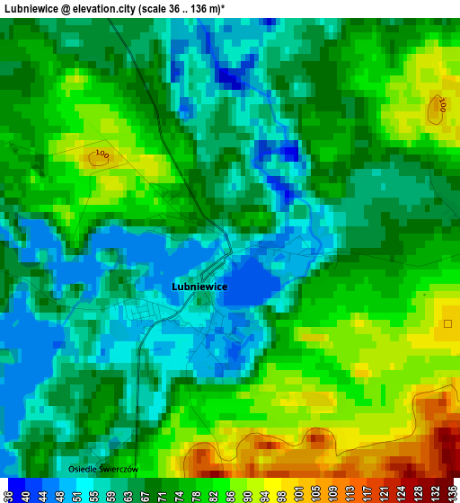
Below is the Elevation map of Lubniewice, which displays elevation range with different colors. Scale of the first map is from 36 to 136 m (118 to 446 ft) with average elevation of 71.7 meters (=235 ft) [note 1]
These maps also provides idea of topography and contour of this city, they are displayed at different zoom levels. More info about maps, scale and edge coordinates you can find below images.
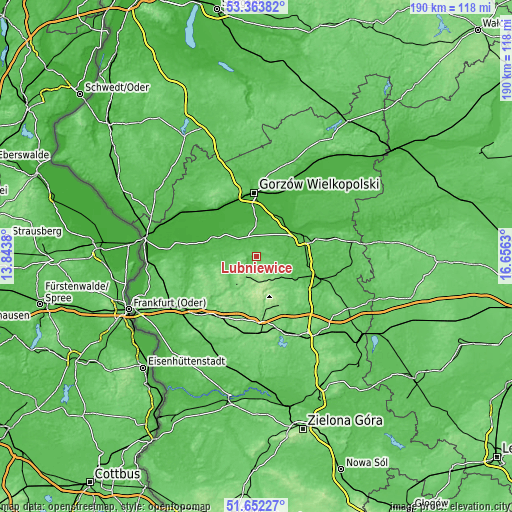
| \ | Map #1 | Topo.Map |
| Scale [m] | 36..136 m | × |
| Scale [ft] | 118..446 ft | × |
| Average | 71.7 m = 235 ft | × |
| Width | 5.95 km = 3.7 mi | 190.3 km = 118.2 mi |
| Height | 5.95 km = 3.7 mi | 190.3 km = 118.2 mi |
| ↑Max Latitude | 52.543114° | 53.36382° |
| Latitude at center | 52.51638° | 52.51638° |
| ↓Min Latitude | 52.48963° | 51.65227° |
| ← Min Longitude | 15.206105° | 13.8438° |
| Longitude center | 15.25005° | 15.25005° |
| →Max Longitude | 15.293995° | 16.6563° |
Nearby cities:
Cities around Lubniewice sort by population:
• Gorzów Wielkopolski elevation 34 m
24.5 km,  356°
356°
• Międzyrzecz 51 m
23.6 km,  109°
109°
• Sulęcin 78 m
12.1 km,  228°
228°
• Skwierzyna 30 m
19.6 km,  62°
62°
• Torzym 94 m
25.3 km,  206°
206°
• Łagów 119 m
20.5 km,  170°
170°
• Krzeszyce 19 m
18 km,  294°
294°
• Bledzew 41 m
11.1 km,  89°
89°
• Bogdaniec 24 m
22.7 km,  327°
327°
• Jenin 23 m
22.5 km, 332°
• Sieniawa 134 m
19.1 km,  153°
153°
• Deszczno 20 m
17.7 km,  15°
15°
Multilingual:
 En español:
Lubniewice elevación 56 m.
 En France:
Lubniewice élévation 56 m.
 Auf Deutsch:
Lubniewice höhe über dem Meeresspiegel ist 56 m.

Sources and notes:
- [note 1] Map square and city borders are not equal. Map elevation data is calculated only from area inside that square.
- [src 1] Elevation data from geonames database provided with same terms of usage.
- [src 2] The elevation map of Lubniewice is generated using elevation data from NASA's 3 arcsec (90m) resolution SRTM data.
- [src 3] Base (background) map © OpenStreetMap contributors tiles are generated by Geofabrik and OpenTopoMap.
Copyright & License:
This Lubniewice Elevation Map is licensed under CC BY-SA. You may reuse any part from this page, if you give a proper credit by linking to this URL:
 More info on terms of use page.