Grudziądz elevation
Grudziądz (Kujawsko-Pomorskie), Poland elevation is 22 meters and Grudziądz elevation in feet is 72 ft above sea level [src 1]. Grudziądz is a populated place (feature code) with elevation that is 169 meters (554 ft) smaller than average city elevation in Poland.
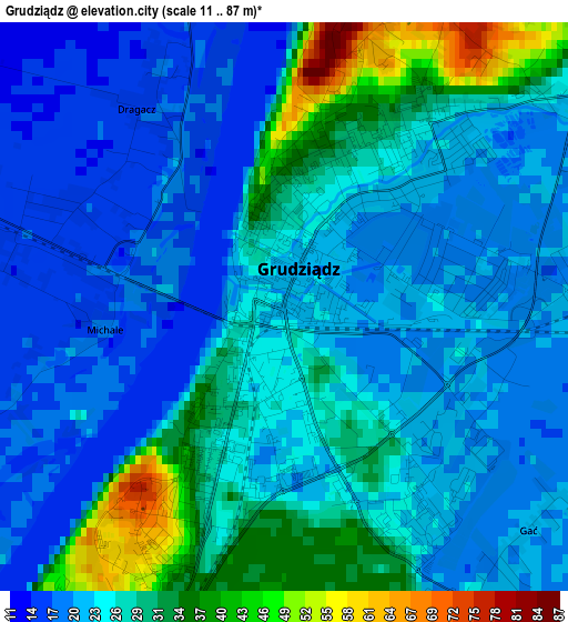
Below is the Elevation map of Grudziądz, which displays elevation range with different colors. Scale of the first map is from 11 to 87 m (36 to 285 ft) with average elevation of 24.6 meters (=81 ft) [note 1]
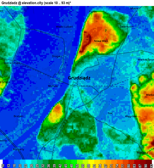
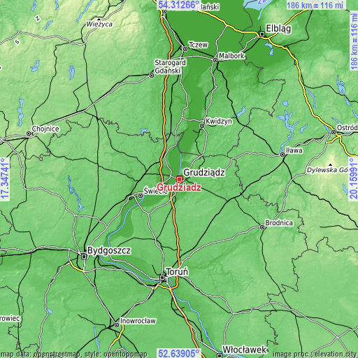
These maps also provides idea of topography and contour of this city, they are displayed at different zoom levels. More info about maps, scale and edge coordinates you can find below images.
| \ | Map #1 | Map #2 | Topo.Map |
| Scale [m] | 11..87 m | 10..93 m | × |
| Scale [ft] | 36..285 ft | 33..305 ft | × |
| Average | 24.6 m = 81 ft | 26.5 m = 87 ft | × |
| Width | 5.82 km = 3.6 mi | 11.63 km = 7.2 mi | 186.1 km = 115.6 mi |
| Height | 5.82 km = 3.6 mi | 11.63 km = 7.2 mi | 186.1 km = 115.6 mi |
| ↑Max Latitude | 53.510251° | 53.536377° | 54.31266° |
| Latitude at center | 53.48411° | 53.48411° | 53.48411° |
| ↓Min Latitude | 53.457952° | 53.431779° | 52.63905° |
| ← Min Longitude | 18.709715° | 18.665769° | 17.34741° |
| Longitude center | 18.75366° | 18.75366° | 18.75366° |
| →Max Longitude | 18.797605° | 18.841551° | 20.15991° |
Nearby cities:
Cities around Grudziądz sort by population:
• Świecie elevation 41 m
21.9 km,  247°
247°
• Nowe 74 m
18.4 km,  354°
354°
• Łasin 92 m
22.5 km,  80°
80°
• Gardeja 84 m
19 km,  42°
42°
• Warlubie 72 m
13.9 km,  325°
325°
• Sadlinki 16 m
21.5 km,  20°
20°
• Radzyń Chełmiński 89 m
16.4 km,  132°
132°
• Jeżewo 89 m
17.4 km,  279°
279°
• Lisewo 102 m
21.4 km,  191°
191°
• Gruta 93 m
13.9 km,  104°
104°
• Rogóźno 77 m
12.9 km,  63°
63°
• Płużnica 96 m
20.9 km,  175°
175°
Multilingual:
 En español:
Grudziądz elevación 22 m.
 En France:
Grudziądz élévation 22 m.
 Auf Deutsch:
Graudenz höhe über dem Meeresspiegel ist 22 m.
 На русском:
Грудзендз, Грудзёндз высота над уровнем моря 22 м
Sources and notes:
- [note 1] Map square and city borders are not equal. Map elevation data is calculated only from area inside that square.
- [src 1] Elevation data from geonames database provided with same terms of usage.
- [src 2] The elevation map of Grudziądz is generated using elevation data from NASA's 3 arcsec (90m) resolution SRTM data.
- [src 3] Base (background) map © OpenStreetMap contributors tiles are generated by Geofabrik and OpenTopoMap.
Copyright & License:
This Grudziądz Elevation Map is licensed under CC BY-SA. You may reuse any part from this page, if you give a proper credit by linking to this URL:
 More info on terms of use page.