Lisewo elevation
Lisewo (Kujawsko-Pomorskie, Powiat chełmiński), Poland elevation is 102 meters and Lisewo elevation in feet is 335 ft above sea level [src 1]. Lisewo is a populated place (feature code) with elevation that is 89 meters (292 ft) smaller than average city elevation in Poland.
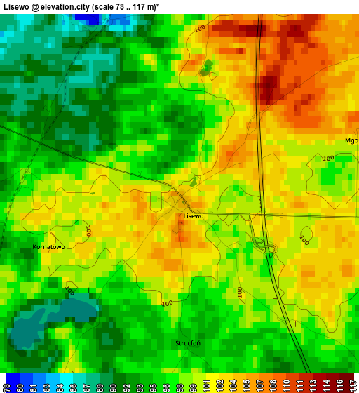
Below is the Elevation map of Lisewo, which displays elevation range with different colors. Scale of the first map is from 78 to 117 m (256 to 384 ft) with average elevation of 97.8 meters (=321 ft) [note 1]
These maps also provides idea of topography and contour of this city, they are displayed at different zoom levels. More info about maps, scale and edge coordinates you can find below images.
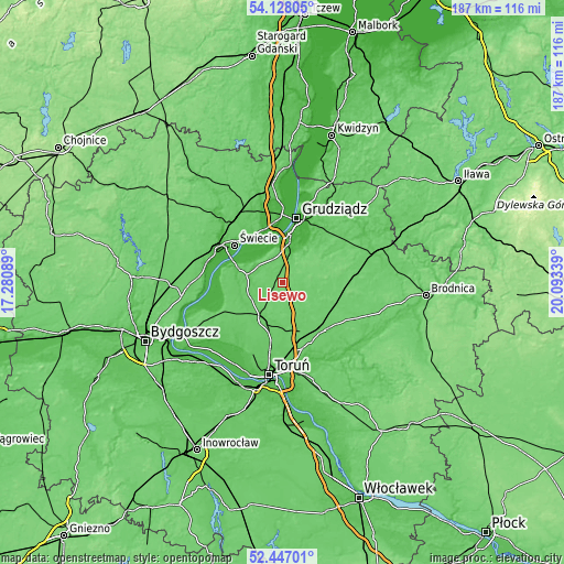
| \ | Map #1 | Topo.Map |
| Scale [m] | 78..117 m | × |
| Scale [ft] | 256..384 ft | × |
| Average | 97.8 m = 321 ft | × |
| Width | 5.84 km = 3.6 mi | 186.9 km = 116.1 mi |
| Height | 5.84 km = 3.6 mi | 186.9 km = 116.1 mi |
| ↑Max Latitude | 53.322057° | 54.12805° |
| Latitude at center | 53.2958° | 53.2958° |
| ↓Min Latitude | 53.269527° | 52.44701° |
| ← Min Longitude | 18.643195° | 17.28089° |
| Longitude center | 18.68714° | 18.68714° |
| →Max Longitude | 18.731085° | 20.09339° |
Nearby cities:
Cities around Lisewo sort by population:
• Grudziądz elevation 22 m
21.4 km,  11°
11°
• Świecie 41 m
20.3 km,  308°
308°
• Chełmno 72 m
18.4 km,  288°
288°
• Chełmża 88 m
13.5 km,  203°
203°
• Wąbrzeźno 105 m
17.4 km,  95°
95°
• Kowalewo Pomorskie 92 m
21.1 km,  138°
138°
• Unisław 89 m
22.1 km,  245°
245°
• Radzyń Chełmiński 89 m
19.3 km,  59°
59°
• Gruta 93 m
25 km,  45°
45°
• Łysomice 80 m
23.7 km,  190°
190°
• Łubianka 76 m
22.2 km,  218°
218°
• Płużnica 96 m
6 km,  89°
89°
Multilingual:
 En español:
Lisewo elevación 102 m.
 En France:
Lisewo élévation 102 m.


Sources and notes:
- [note 1] Map square and city borders are not equal. Map elevation data is calculated only from area inside that square.
- [src 1] Elevation data from geonames database provided with same terms of usage.
- [src 2] The elevation map of Lisewo is generated using elevation data from NASA's 3 arcsec (90m) resolution SRTM data.
- [src 3] Base (background) map © OpenStreetMap contributors tiles are generated by Geofabrik and OpenTopoMap.
Copyright & License:
This Lisewo Elevation Map is licensed under CC BY-SA. You may reuse any part from this page, if you give a proper credit by linking to this URL:
 More info on terms of use page.