Radzyń Chełmiński elevation
Radzyń Chełmiński (Kujawsko-Pomorskie, Powiat grudziądzki), Poland elevation is 89 meters and Radzyń Chełmiński elevation in feet is 292 ft above sea level [src 1]. Radzyń Chełmiński is a populated place (feature code) with elevation that is 102 meters (335 ft) smaller than average city elevation in Poland.
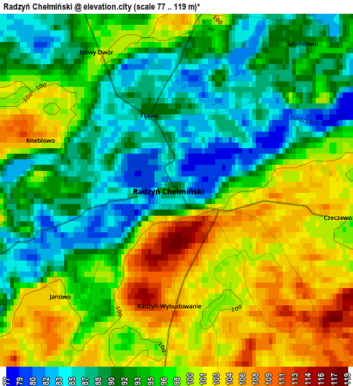
Below is the Elevation map of Radzyń Chełmiński, which displays elevation range with different colors. Scale of the first map is from 77 to 119 m (253 to 390 ft) with average elevation of 95.2 meters (=312 ft) [note 1]
These maps also provides idea of topography and contour of this city, they are displayed at different zoom levels. More info about maps, scale and edge coordinates you can find below images.
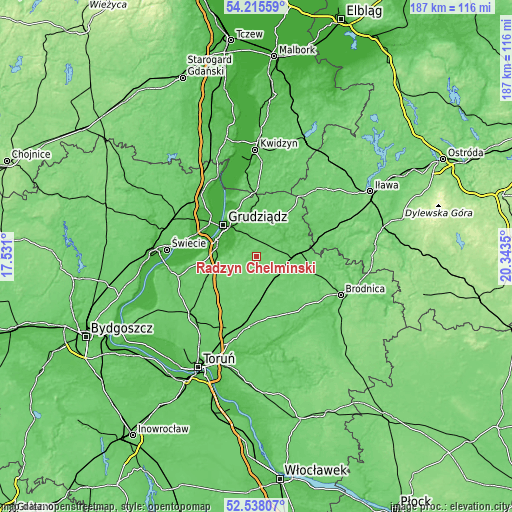
| \ | Map #1 | Topo.Map |
| Scale [m] | 77..119 m | × |
| Scale [ft] | 253..390 ft | × |
| Average | 95.2 m = 312 ft | × |
| Width | 5.83 km = 3.6 mi | 186.5 km = 115.9 mi |
| Height | 5.83 km = 3.6 mi | 186.5 km = 115.9 mi |
| ↑Max Latitude | 53.411292° | 54.21559° |
| Latitude at center | 53.38509° | 53.38509° |
| ↓Min Latitude | 53.358871° | 52.53807° |
| ← Min Longitude | 18.893305° | 17.531° |
| Longitude center | 18.93725° | 18.93725° |
| →Max Longitude | 18.981195° | 20.3435° |
Nearby cities:
Cities around Radzyń Chełmiński sort by population:
• Grudziądz elevation 22 m
16.4 km,  312°
312°
• Wąbrzeźno 105 m
11.7 km,  176°
176°
• Jabłonowo Pomorskie 89 m
14.5 km,  87°
87°
• Łasin 92 m
17.8 km,  34°
34°
• Lisewo 102 m
19.3 km,  239°
239°
• Gruta 93 m
7.7 km,  9°
9°
• Rogóźno 77 m
16.8 km,  358°
358°
• Świecie nad Osą 58 m
12.7 km,  58°
58°
• Dębowa Łąka 94 m
17.9 km,  143°
143°
• Płużnica 96 m
14.5 km,  227°
227°
• Bobrowo 96 m
24.7 km,  116°
116°
• Książki 101 m
10.8 km, 124°
Multilingual:
 En español:
Radzyń Chełmiński elevación 89 m.
 En France:
Radzyń Chełmiński élévation 89 m.
 Auf Deutsch:
Radzyń Chełmiński höhe über dem Meeresspiegel ist 89 m.

Sources and notes:
- [note 1] Map square and city borders are not equal. Map elevation data is calculated only from area inside that square.
- [src 1] Elevation data from geonames database provided with same terms of usage.
- [src 2] The elevation map of Radzyń Chełmiński is generated using elevation data from NASA's 3 arcsec (90m) resolution SRTM data.
- [src 3] Base (background) map © OpenStreetMap contributors tiles are generated by Geofabrik and OpenTopoMap.
Copyright & License:
This Radzyń Chełmiński Elevation Map is licensed under CC BY-SA. You may reuse any part from this page, if you give a proper credit by linking to this URL:
 More info on terms of use page.