Izdebnik elevation
Izdebnik (Lesser Poland, Powiat wadowicki), Poland elevation is 258 meters and Izdebnik elevation in feet is 846 ft above sea level [src 1]. Izdebnik is a populated place (feature code) with elevation that is 67 meters (220 ft) bigger than average city elevation in Poland.
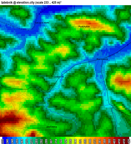
Below is the Elevation map of Izdebnik, which displays elevation range with different colors. Scale of the first map is from 233 to 425 m (764 to 1394 ft) with average elevation of 299.9 meters (=984 ft) [note 1]
These maps also provides idea of topography and contour of this city, they are displayed at different zoom levels. More info about maps, scale and edge coordinates you can find below images.
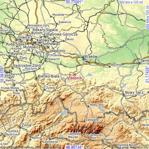
| \ | Map #1 | Topo.Map |
| Scale [m] | 233..425 m | × |
| Scale [ft] | 764..1394 ft | × |
| Average | 299.9 m = 984 ft | × |
| Width | 6.3 km = 3.9 mi | 201.6 km = 125.3 mi |
| Height | 6.3 km = 3.9 mi | 201.5 km = 125.2 mi |
| ↑Max Latitude | 49.900494° | 50.77001° |
| Latitude at center | 49.87218° | 49.87218° |
| ↓Min Latitude | 49.843849° | 48.95734° |
| ← Min Longitude | 19.724065° | 18.36176° |
| Longitude center | 19.76801° | 19.76801° |
| →Max Longitude | 19.811955° | 21.17426° |
Nearby cities:
Cities around Izdebnik sort by population:
• Sułkowice elevation 290 m
4.2 km,  146°
146°
• Kalwaria Zebrzydowska 327 m
6.5 km,  265°
265°
• Rudnik 327 m
6.1 km,  111°
111°
• Brody 291 m
5.1 km,  264°
264°
• Wola Radziszowska 229 m
4 km,  21°
21°
• Lanckorona 466 m
4.8 km,  231°
231°
• Zebrzydowice 279 m
7.1 km,  286°
286°
• Skawinki 376 m
6.8 km,  215°
215°
• Harbutowice 362 m
6.7 km,  172°
172°
• Krzywaczka 250 m
5.2 km,  62°
62°
• Leńcze 307 m
3.8 km,  321°
321°
• Bęczarka 321 m
7.1 km,  84°
84°
Multilingual:
 En español:
Izdebnik elevación 258 m.
 En France:
Izdebnik élévation 258 m.
 Auf Deutsch:
Izdebnik höhe über dem Meeresspiegel ist 258 m.

Sources and notes:
- [note 1] Map square and city borders are not equal. Map elevation data is calculated only from area inside that square.
- [src 1] Elevation data from geonames database provided with same terms of usage.
- [src 2] The elevation map of Izdebnik is generated using elevation data from NASA's 3 arcsec (90m) resolution SRTM data.
- [src 3] Base (background) map © OpenStreetMap contributors tiles are generated by Geofabrik and OpenTopoMap.
Copyright & License:
This Izdebnik Elevation Map is licensed under CC BY-SA. You may reuse any part from this page, if you give a proper credit by linking to this URL:
 More info on terms of use page.