Zebrzydowice elevation
Zebrzydowice (Lesser Poland, Powiat wadowicki), Poland elevation is 279 meters and Zebrzydowice elevation in feet is 915 ft above sea level [src 1]. Zebrzydowice is a populated place (feature code) with elevation that is 88 meters (289 ft) bigger than average city elevation in Poland.
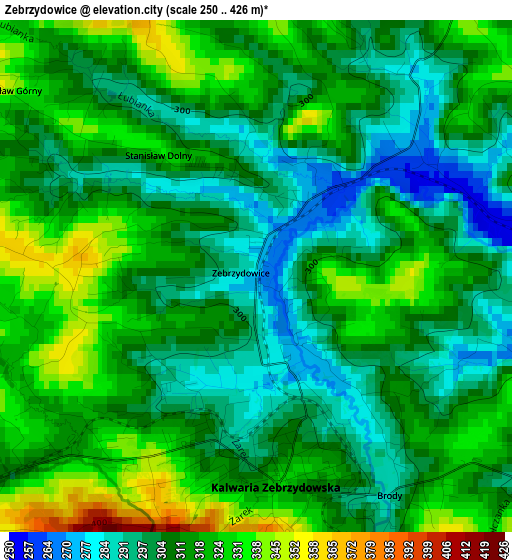
Below is the Elevation map of Zebrzydowice, which displays elevation range with different colors. Scale of the first map is from 250 to 426 m (820 to 1398 ft) with average elevation of 311.3 meters (=1021 ft) [note 1]
These maps also provides idea of topography and contour of this city, they are displayed at different zoom levels. More info about maps, scale and edge coordinates you can find below images.
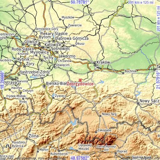
| \ | Map #1 | Topo.Map |
| Scale [m] | 250..426 m | × |
| Scale [ft] | 820..1398 ft | × |
| Average | 311.3 m = 1021 ft | × |
| Width | 6.3 km = 3.9 mi | 201.5 km = 125.2 mi |
| Height | 6.3 km = 3.9 mi | 201.5 km = 125.2 mi |
| ↑Max Latitude | 49.918624° | 50.78781° |
| Latitude at center | 49.89032° | 49.89032° |
| ↓Min Latitude | 49.862° | 48.97582° |
| ← Min Longitude | 19.628965° | 18.26666° |
| Longitude center | 19.67291° | 19.67291° |
| →Max Longitude | 19.716855° | 21.07916° |
Nearby cities:
Cities around Zebrzydowice sort by population:
• Kalwaria Zebrzydowska elevation 327 m
2.5 km,  173°
173°
• Brody 291 m
3.1 km,  145°
145°
• Przytkowice 328 m
3.2 km,  16°
16°
• Stanisław Dolny 332 m
2.1 km,  318°
318°
• Lanckorona 466 m
5.9 km, 148°
• Wysoka 338 m
5.3 km,  290°
290°
• Leńcze 307 m
4.6 km,  77°
77°
• Barwałd Średni 334 m
6.3 km,  244°
244°
• Stronie 419 m
6.6 km,  178°
178°
• Barwałd Górny 295 m
5.1 km,  231°
231°
• Sosnowice 229 m
6.3 km,  28°
28°
• Stanisław Górny 351 m
3.9 km,  307°
307°
Multilingual:
 En español:
Zebrzydowice elevación 279 m.
 En France:
Zebrzydowice élévation 279 m.
 Auf Deutsch:
Zebrzydowice höhe über dem Meeresspiegel ist 279 m.

Sources and notes:
- [note 1] Map square and city borders are not equal. Map elevation data is calculated only from area inside that square.
- [src 1] Elevation data from geonames database provided with same terms of usage.
- [src 2] The elevation map of Zebrzydowice is generated using elevation data from NASA's 3 arcsec (90m) resolution SRTM data.
- [src 3] Base (background) map © OpenStreetMap contributors tiles are generated by Geofabrik and OpenTopoMap.
Copyright & License:
This Zebrzydowice Elevation Map is licensed under CC BY-SA. You may reuse any part from this page, if you give a proper credit by linking to this URL:
 More info on terms of use page.