Kiszkowo elevation
Kiszkowo (Greater Poland, Powiat gnieźnieński), Poland elevation is 94 meters and Kiszkowo elevation in feet is 308 ft above sea level [src 1]. Kiszkowo is a seat of a third-order administrative division (feature code) with elevation that is 97 meters (318 ft) smaller than average city elevation in Poland.
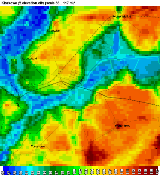
Below is the Elevation map of Kiszkowo, which displays elevation range with different colors. Scale of the first map is from 86 to 117 m (282 to 384 ft) with average elevation of 101.4 meters (=333 ft) [note 1]
These maps also provides idea of topography and contour of this city, they are displayed at different zoom levels. More info about maps, scale and edge coordinates you can find below images.
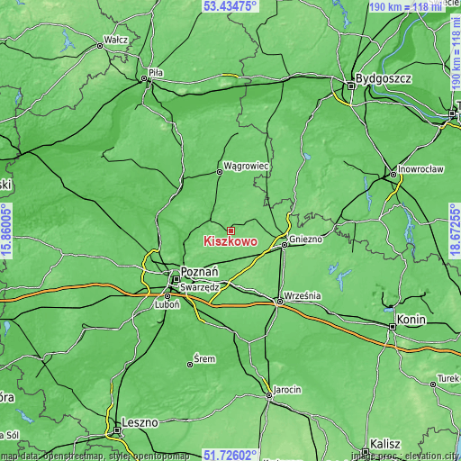
| \ | Map #1 | Topo.Map |
| Scale [m] | 86..117 m | × |
| Scale [ft] | 282..384 ft | × |
| Average | 101.4 m = 333 ft | × |
| Width | 5.94 km = 3.7 mi | 190 km = 118.1 mi |
| Height | 5.94 km = 3.7 mi | 190 km = 118.1 mi |
| ↑Max Latitude | 52.6154° | 53.43475° |
| Latitude at center | 52.58871° | 52.58871° |
| ↓Min Latitude | 52.562004° | 51.72602° |
| ← Min Longitude | 17.222355° | 15.86005° |
| Longitude center | 17.2663° | 17.2663° |
| →Max Longitude | 17.310245° | 18.67255° |
Nearby cities:
Cities around Kiszkowo sort by population:
• Gniezno elevation 120 m
22.2 km,  105°
105°
• Swarzędz 92 m
23.1 km,  212°
212°
• Murowana Goślina 78 m
17.4 km,  264°
264°
• Kostrzyn 101 m
21.3 km,  186°
186°
• Pobiedziska 109 m
12.4 km,  173°
173°
• Skoki 85 m
11.7 km,  322°
322°
• Kłecko 107 m
12.1 km,  66°
66°
• Czerniejewo 109 m
23.5 km,  140°
140°
• Mieścisko 96 m
17.8 km,  14°
14°
• Kobylnica 89 m
20.4 km,  218°
218°
• Łubowo 115 m
15.3 km,  124°
124°
• Mieleszyn 115 m
18 km,  60°
60°
Multilingual:
 En español:
Kiszkowo elevación 94 m.
 En France:
Kiszkowo élévation 94 m.


Sources and notes:
- [note 1] Map square and city borders are not equal. Map elevation data is calculated only from area inside that square.
- [src 1] Elevation data from geonames database provided with same terms of usage.
- [src 2] The elevation map of Kiszkowo is generated using elevation data from NASA's 3 arcsec (90m) resolution SRTM data.
- [src 3] Base (background) map © OpenStreetMap contributors tiles are generated by Geofabrik and OpenTopoMap.
Copyright & License:
This Kiszkowo Elevation Map is licensed under CC BY-SA. You may reuse any part from this page, if you give a proper credit by linking to this URL:
 More info on terms of use page.