Mieleszyn elevation
Mieleszyn (Greater Poland, Powiat gnieźnieński), Poland elevation is 115 meters and Mieleszyn elevation in feet is 377 ft above sea level [src 1]. Mieleszyn is a seat of a third-order administrative division (feature code) with elevation that is 76 meters (249 ft) smaller than average city elevation in Poland.
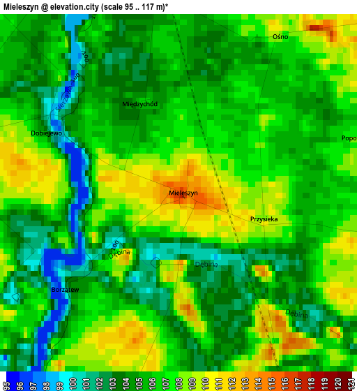
Below is the Elevation map of Mieleszyn, which displays elevation range with different colors. Scale of the first map is from 95 to 117 m (312 to 384 ft) with average elevation of 105.7 meters (=347 ft) [note 1]
These maps also provides idea of topography and contour of this city, they are displayed at different zoom levels. More info about maps, scale and edge coordinates you can find below images.
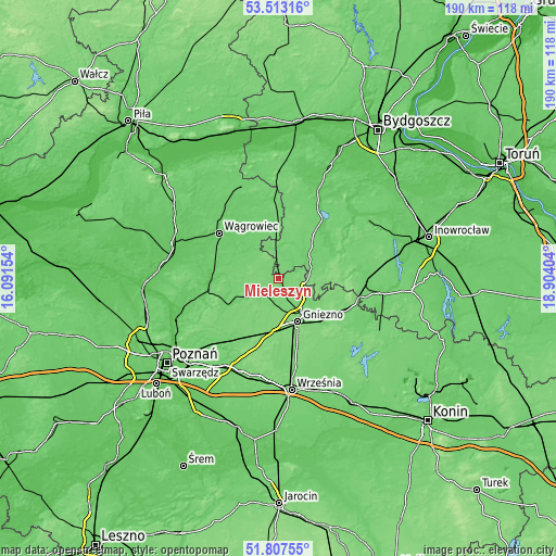
| \ | Map #1 | Topo.Map |
| Scale [m] | 95..117 m | × |
| Scale [ft] | 312..384 ft | × |
| Average | 105.7 m = 347 ft | × |
| Width | 5.93 km = 3.7 mi | 189.6 km = 117.8 mi |
| Height | 5.93 km = 3.7 mi | 189.6 km = 117.8 mi |
| ↑Max Latitude | 52.695321° | 53.51316° |
| Latitude at center | 52.66868° | 52.66868° |
| ↓Min Latitude | 52.642022° | 51.80755° |
| ← Min Longitude | 17.453845° | 16.09154° |
| Longitude center | 17.49779° | 17.49779° |
| →Max Longitude | 17.541735° | 18.90404° |
Nearby cities:
Cities around Mieleszyn sort by population:
• Gniezno elevation 120 m
15.9 km,  158°
158°
• Żnin 82 m
25.1 km,  36°
36°
• Trzemeszno 107 m
25 km,  118°
118°
• Janowiec Wielkopolski 97 m
9.7 km,  356°
356°
• Skoki 85 m
22.7 km,  270°
270°
• Kłecko 107 m
6.1 km,  227°
227°
• Damasławek 110 m
19 km,  0°
0°
• Mieścisko 96 m
13.9 km,  306°
306°
• Rogowo 96 m
12.1 km,  59°
59°
• Kiszkowo 94 m
18 km,  240°
240°
• Gąsawa 86 m
20.6 km, 57°
• Łubowo 115 m
17.7 km,  189°
189°
Multilingual:
 En español:
Mieleszyn elevación 115 m.
 En France:
Mieleszyn élévation 115 m.
 Auf Deutsch:
Mieleszyn höhe über dem Meeresspiegel ist 115 m.

Sources and notes:
- [note 1] Map square and city borders are not equal. Map elevation data is calculated only from area inside that square.
- [src 1] Elevation data from geonames database provided with same terms of usage.
- [src 2] The elevation map of Mieleszyn is generated using elevation data from NASA's 3 arcsec (90m) resolution SRTM data.
- [src 3] Base (background) map © OpenStreetMap contributors tiles are generated by Geofabrik and OpenTopoMap.
Copyright & License:
This Mieleszyn Elevation Map is licensed under CC BY-SA. You may reuse any part from this page, if you give a proper credit by linking to this URL:
 More info on terms of use page.