Ozimek elevation
Ozimek (Opole Voivodeship, Powiat opolski), Poland elevation is 183 meters and Ozimek elevation in feet is 600 ft above sea level [src 1]. Ozimek is a populated place (feature code) with elevation that is 8 meters (26 ft) smaller than average city elevation in Poland.
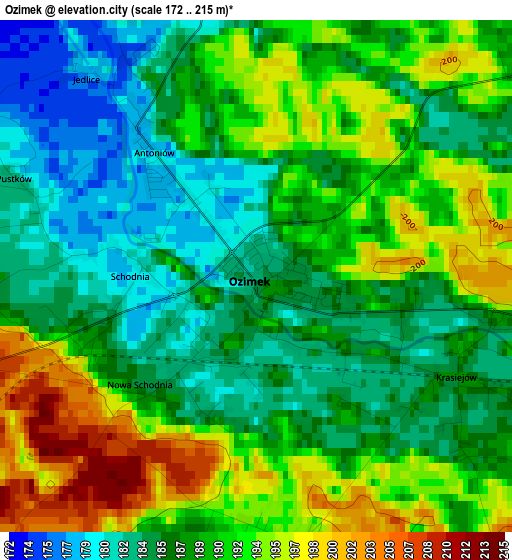
Below is the Elevation map of Ozimek, which displays elevation range with different colors. Scale of the first map is from 172 to 215 m (564 to 705 ft) with average elevation of 188.8 meters (=619 ft) [note 1]
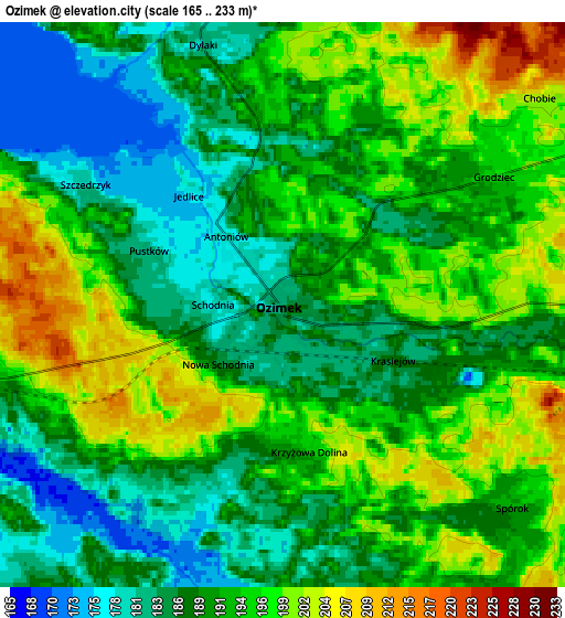
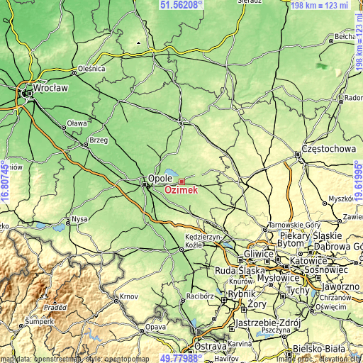
These maps also provides idea of topography and contour of this city, they are displayed at different zoom levels. More info about maps, scale and edge coordinates you can find below images.
| \ | Map #1 | Map #2 | Topo.Map |
| Scale [m] | 172..215 m | 165..233 m | × |
| Scale [ft] | 564..705 ft | 541..764 ft | × |
| Average | 188.8 m = 619 ft | 191.3 m = 628 ft | × |
| Width | 6.19 km = 3.8 mi | 12.38 km = 7.7 mi | 198.2 km = 123.2 mi |
| Height | 6.19 km = 3.8 mi | 12.38 km = 7.7 mi | 198.1 km = 123.1 mi |
| ↑Max Latitude | 50.707278° | 50.7351° | 51.56208° |
| Latitude at center | 50.67944° | 50.67944° | 50.67944° |
| ↓Min Latitude | 50.651585° | 50.623714° | 49.77988° |
| ← Min Longitude | 18.169755° | 18.125809° | 16.80745° |
| Longitude center | 18.2137° | 18.2137° | 18.2137° |
| →Max Longitude | 18.257645° | 18.301591° | 19.61995° |
Nearby cities:
Cities around Ozimek sort by population:
• Strzelce Opolskie elevation 236 m
19.7 km,  161°
161°
• Dobrodzień 234 m
17.2 km,  71°
71°
• Tarnów Opolski 178 m
14.7 km,  218°
218°
• Jemielnica 215 m
18.9 km,  142°
142°
• Kolonowskie 199 m
12.4 km,  103°
103°
• Łubniany 168 m
19.1 km,  308°
308°
• Zębowice 219 m
13.1 km,  44°
44°
• Nakło 178 m
13 km,  211°
211°
• Chrząstowice 164 m
10 km,  261°
261°
• Izbicko 186 m
12.7 km,  198°
198°
• Bierdzany 198 m
16 km,  345°
345°
• Węgry 160 m
15.5 km,  297°
297°
Multilingual:
 En español:
Ozimek elevación 183 m.
 En France:
Ozimek élévation 183 m.


Sources and notes:
- [note 1] Map square and city borders are not equal. Map elevation data is calculated only from area inside that square.
- [src 1] Elevation data from geonames database provided with same terms of usage.
- [src 2] The elevation map of Ozimek is generated using elevation data from NASA's 3 arcsec (90m) resolution SRTM data.
- [src 3] Base (background) map © OpenStreetMap contributors tiles are generated by Geofabrik and OpenTopoMap.
Copyright & License:
This Ozimek Elevation Map is licensed under CC BY-SA. You may reuse any part from this page, if you give a proper credit by linking to this URL:
 More info on terms of use page.