Połomia elevation
Połomia (Silesia, Powiat wodzisławski), Poland elevation is 245 meters and Połomia elevation in feet is 804 ft above sea level [src 1]. Połomia is a populated place (feature code) with elevation that is 54 meters (177 ft) bigger than average city elevation in Poland.
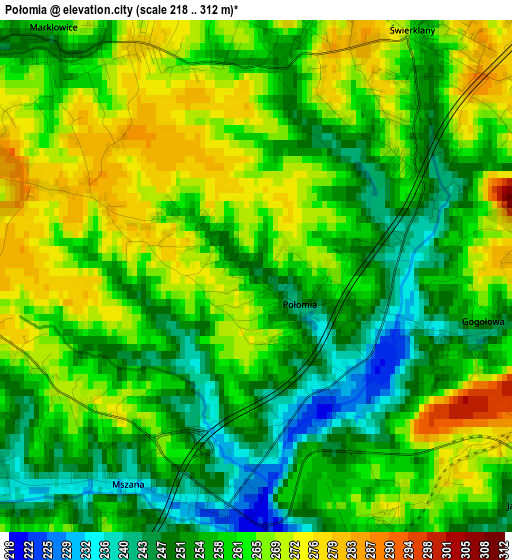
Below is the Elevation map of Połomia, which displays elevation range with different colors. Scale of the first map is from 218 to 312 m (715 to 1024 ft) with average elevation of 260 meters (=853 ft) [note 1]
These maps also provides idea of topography and contour of this city, they are displayed at different zoom levels. More info about maps, scale and edge coordinates you can find below images.
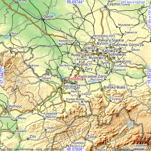
| \ | Map #1 | Topo.Map |
| Scale [m] | 218..312 m | × |
| Scale [ft] | 715..1024 ft | × |
| Average | 260 m = 853 ft | × |
| Width | 6.28 km = 3.9 mi | 201.1 km = 125 mi |
| Height | 6.28 km = 3.9 mi | 201 km = 124.9 mi |
| ↑Max Latitude | 50.020094° | 50.88744° |
| Latitude at center | 49.99185° | 49.99185° |
| ↓Min Latitude | 49.963589° | 49.07926° |
| ← Min Longitude | 18.507075° | 17.14477° |
| Longitude center | 18.55102° | 18.55102° |
| →Max Longitude | 18.594965° | 19.95727° |
Nearby cities:
Cities around Połomia sort by population:
• Jastrzębie Zdrój elevation 237 m
4.4 km,  157°
157°
• Wodzisław Śląski 246 m
5.8 km,  283°
283°
• Radlin 287 m
8.4 km,  320°
320°
• Markłowice 253 m
3.5 km, 322°
• Świerklany Górne 284 m
4.9 km,  35°
35°
• Jankowice Rybnickie 267 m
5.9 km,  357°
357°
• Gołkowice 242 m
9 km,  196°
196°
• Mszana 237 m
3 km,  213°
213°
• Skrzyszów 258 m
6.5 km,  222°
222°
• Świerklany Dolne 264 m
3.5 km,  32°
32°
• Turza Śląska 225 m
8.4 km,  254°
254°
• Krzyżowice 253 m
8.7 km,  94°
94°
Multilingual:
 En español:
Połomia elevación 245 m.
 En France:
Połomia élévation 245 m.


Sources and notes:
- [note 1] Map square and city borders are not equal. Map elevation data is calculated only from area inside that square.
- [src 1] Elevation data from geonames database provided with same terms of usage.
- [src 2] The elevation map of Połomia is generated using elevation data from NASA's 3 arcsec (90m) resolution SRTM data.
- [src 3] Base (background) map © OpenStreetMap contributors tiles are generated by Geofabrik and OpenTopoMap.
Copyright & License:
This Połomia Elevation Map is licensed under CC BY-SA. You may reuse any part from this page, if you give a proper credit by linking to this URL:
 More info on terms of use page.