Skrzyszów elevation
Skrzyszów (Silesia, Powiat wodzisławski), Poland elevation is 258 meters and Skrzyszów elevation in feet is 846 ft above sea level [src 1]. Skrzyszów is a populated place (feature code) with elevation that is 67 meters (220 ft) bigger than average city elevation in Poland.
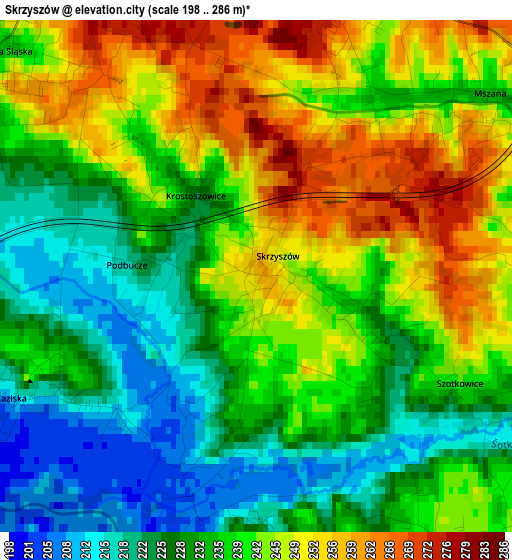
Below is the Elevation map of Skrzyszów, which displays elevation range with different colors. Scale of the first map is from 198 to 286 m (650 to 938 ft) with average elevation of 237.7 meters (=780 ft) [note 1]
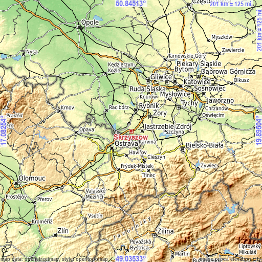
These maps also provides idea of topography and contour of this city, they are displayed at different zoom levels. More info about maps, scale and edge coordinates you can find below images.
| \ | Map #1 | Topo.Map |
| Scale [m] | 198..286 m | × |
| Scale [ft] | 650..938 ft | × |
| Average | 237.7 m = 780 ft | × |
| Width | 6.29 km = 3.9 mi | 201.2 km = 125 mi |
| Height | 6.29 km = 3.9 mi | 201.2 km = 125 mi |
| ↑Max Latitude | 49.976999° | 50.84513° |
| Latitude at center | 49.94873° | 49.94873° |
| ↓Min Latitude | 49.920444° | 49.03533° |
| ← Min Longitude | 18.444845° | 17.08254° |
| Longitude center | 18.48879° | 18.48879° |
| →Max Longitude | 18.532735° | 19.89504° |
Nearby cities:
Cities around Skrzyszów sort by population:
• Jastrzębie Zdrój elevation 237 m
6.2 km,  83°
83°
• Wodzisław Śląski 246 m
6.2 km,  348°
348°
• Markłowice 253 m
7.9 km,  16°
16°
• Gołkowice 242 m
4.3 km,  154°
154°
• Mszana 237 m
3.6 km,  50°
50°
• Czyżowice 266 m
7.3 km,  303°
303°
• Turza Śląska 225 m
4.5 km,  305°
305°
• Połomia 245 m
6.5 km,  42°
42°
• Gorzyce 243 m
6.5 km,  280°
280°
• Gorzyczki 251 m
6.1 km,  270°
270°
• Godów 204 m
2.8 km,  195°
195°
• Łaziska 214 m
3.3 km,  244°
244°
Multilingual:
 En español:
Skrzyszów elevación 258 m.
 En France:
Skrzyszów élévation 258 m.
 Auf Deutsch:
Skrzyszów höhe über dem Meeresspiegel ist 258 m.

Sources and notes:
- [note 1] Map square and city borders are not equal. Map elevation data is calculated only from area inside that square.
- [src 1] Elevation data from geonames database provided with same terms of usage.
- [src 2] The elevation map of Skrzyszów is generated using elevation data from NASA's 3 arcsec (90m) resolution SRTM data.
- [src 3] Base (background) map © OpenStreetMap contributors tiles are generated by Geofabrik and OpenTopoMap.
Copyright & License:
This Skrzyszów Elevation Map is licensed under CC BY-SA. You may reuse any part from this page, if you give a proper credit by linking to this URL:
 More info on terms of use page.