Sicienko elevation
Sicienko (Kujawsko-Pomorskie, Powiat bydgoski), Poland elevation is 103 meters and Sicienko elevation in feet is 338 ft above sea level [src 1]. Sicienko is a seat of a third-order administrative division (feature code) with elevation that is 88 meters (289 ft) smaller than average city elevation in Poland.
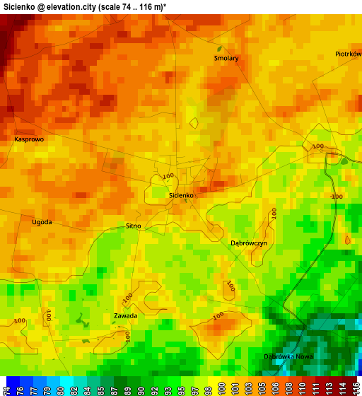
Below is the Elevation map of Sicienko, which displays elevation range with different colors. Scale of the first map is from 74 to 116 m (243 to 381 ft) with average elevation of 100.3 meters (=329 ft) [note 1]
These maps also provides idea of topography and contour of this city, they are displayed at different zoom levels. More info about maps, scale and edge coordinates you can find below images.
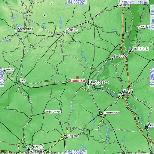
| \ | Map #1 | Topo.Map |
| Scale [m] | 74..116 m | × |
| Scale [ft] | 243..381 ft | × |
| Average | 100.3 m = 329 ft | × |
| Width | 5.85 km = 3.6 mi | 187.3 km = 116.4 mi |
| Height | 5.85 km = 3.6 mi | 187.3 km = 116.4 mi |
| ↑Max Latitude | 53.230184° | 54.03792° |
| Latitude at center | 53.20387° | 53.20387° |
| ↓Min Latitude | 53.17754° | 52.35327° |
| ← Min Longitude | 17.756565° | 16.39426° |
| Longitude center | 17.80051° | 17.80051° |
| →Max Longitude | 17.844455° | 19.20676° |
Nearby cities:
Cities around Sicienko sort by population:
• Bydgoszcz elevation 37 m
16.4 km,  122°
122°
• Fordon 39 m
25.4 km,  104°
104°
• Nakło nad Notecią 76 m
14.9 km,  242°
242°
• Koronowo 65 m
15.2 km,  36°
36°
• Szubin 80 m
22 km,  190°
190°
• Białe Błota 70 m
14.3 km,  147°
147°
• Więcbork 113 m
26.5 km,  308°
308°
• Mrocza 103 m
13.8 km,  288°
288°
• Osielsko 93 m
19 km, 96°
• Sadki 86 m
23.9 km,  258°
258°
• Ślesin 96 m
7.8 km, 236°
• Sośno 130 m
21.9 km,  339°
339°
Multilingual:
 En español:
Sicienko elevación 103 m.
 En France:
Sicienko élévation 103 m.
 Auf Deutsch:
Sicienko höhe über dem Meeresspiegel ist 103 m.

Sources and notes:
- [note 1] Map square and city borders are not equal. Map elevation data is calculated only from area inside that square.
- [src 1] Elevation data from geonames database provided with same terms of usage.
- [src 2] The elevation map of Sicienko is generated using elevation data from NASA's 3 arcsec (90m) resolution SRTM data.
- [src 3] Base (background) map © OpenStreetMap contributors tiles are generated by Geofabrik and OpenTopoMap.
Copyright & License:
This Sicienko Elevation Map is licensed under CC BY-SA. You may reuse any part from this page, if you give a proper credit by linking to this URL:
 More info on terms of use page.