Ślesin elevation
Ślesin (Kujawsko-Pomorskie, Powiat nakielski), Poland elevation is 96 meters and Ślesin elevation in feet is 315 ft above sea level [src 1]. Ślesin is a populated place (feature code) with elevation that is 95 meters (312 ft) smaller than average city elevation in Poland.
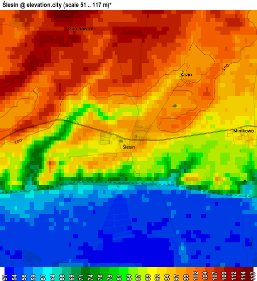
Below is the Elevation map of Ślesin, which displays elevation range with different colors. Scale of the first map is from 51 to 117 m (167 to 384 ft) with average elevation of 84.2 meters (=276 ft) [note 1]
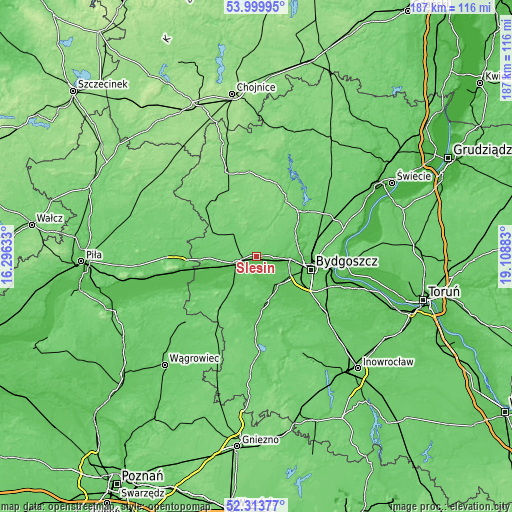
These maps also provides idea of topography and contour of this city, they are displayed at different zoom levels. More info about maps, scale and edge coordinates you can find below images.
| \ | Map #1 | Topo.Map |
| Scale [m] | 51..117 m | × |
| Scale [ft] | 167..384 ft | × |
| Average | 84.2 m = 276 ft | × |
| Width | 5.86 km = 3.6 mi | 187.5 km = 116.5 mi |
| Height | 5.86 km = 3.6 mi | 187.5 km = 116.5 mi |
| ↑Max Latitude | 53.191478° | 53.99995° |
| Latitude at center | 53.16514° | 53.16514° |
| ↓Min Latitude | 53.138786° | 52.31377° |
| ← Min Longitude | 17.658635° | 16.29633° |
| Longitude center | 17.70258° | 17.70258° |
| →Max Longitude | 17.746525° | 19.10883° |
Nearby cities:
Cities around Ślesin sort by population:
• Bydgoszcz elevation 37 m
20.9 km,  102°
102°
• Nakło nad Notecią 76 m
7.2 km,  249°
249°
• Koronowo 65 m
22.7 km,  43°
43°
• Szubin 80 m
17.5 km,  171°
171°
• Białe Błota 70 m
16.2 km,  118°
118°
• Więcbork 113 m
25.3 km,  326°
326°
• Kcynia 141 m
24 km,  216°
216°
• Mrocza 103 m
10.9 km,  322°
322°
• Osielsko 93 m
25.5 km,  85°
85°
• Sadki 86 m
16.9 km,  268°
268°
• Sośno 130 m
24.9 km,  357°
357°
• Sicienko 103 m
7.8 km,  56°
56°
Multilingual:
 En español:
Ślesin elevación 96 m.
 En France:
Ślesin élévation 96 m.


Sources and notes:
- [note 1] Map square and city borders are not equal. Map elevation data is calculated only from area inside that square.
- [src 1] Elevation data from geonames database provided with same terms of usage.
- [src 2] The elevation map of Ślesin is generated using elevation data from NASA's 3 arcsec (90m) resolution SRTM data.
- [src 3] Base (background) map © OpenStreetMap contributors tiles are generated by Geofabrik and OpenTopoMap.
Copyright & License:
This Ślesin Elevation Map is licensed under CC BY-SA. You may reuse any part from this page, if you give a proper credit by linking to this URL:
 More info on terms of use page.