Wieszowa elevation
Wieszowa (Silesia, Powiat tarnogórski), Poland elevation is 275 meters and Wieszowa elevation in feet is 902 ft above sea level [src 1]. Wieszowa is a populated place (feature code) with elevation that is 84 meters (276 ft) bigger than average city elevation in Poland.
Below is the Elevation map of Wieszowa, which displays elevation range with different colors. Scale of the first map is from 235 to 326 m (771 to 1070 ft) with average elevation of 274.6 meters (=901 ft) [note 1]
These maps also provides idea of topography and contour of this city, they are displayed at different zoom levels. More info about maps, scale and edge coordinates you can find below images.
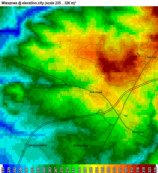
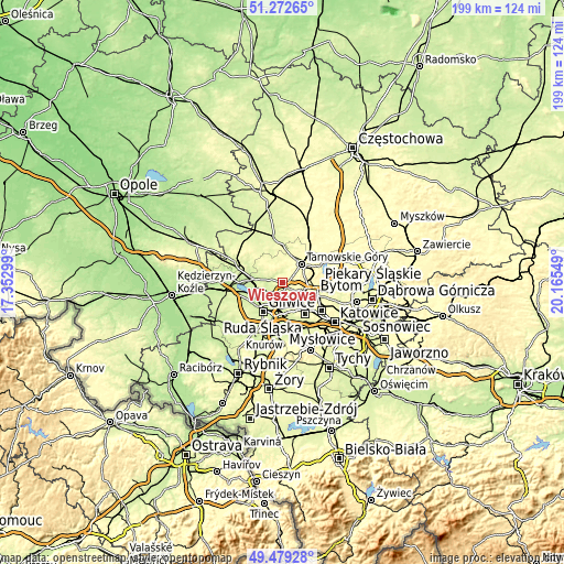
| \ | Map #1 | Topo.Map |
| Scale [m] | 235..326 m | × |
| Scale [ft] | 771..1070 ft | × |
| Average | 274.6 m = 901 ft | × |
| Width | 6.23 km = 3.9 mi | 199.4 km = 123.9 mi |
| Height | 6.23 km = 3.9 mi | 199.4 km = 123.9 mi |
| ↑Max Latitude | 50.412453° | 51.27265° |
| Latitude at center | 50.38444° | 50.38444° |
| ↓Min Latitude | 50.356411° | 49.47928° |
| ← Min Longitude | 18.715295° | 17.35299° |
| Longitude center | 18.75924° | 18.75924° |
| →Max Longitude | 18.803185° | 20.16549° |
Nearby cities:
Cities around Wieszowa sort by population:
• Gliwice elevation 219 m
11.3 km,  211°
211°
• Zabrze 258 m
6.9 km,  164°
164°
• Bytom 285 m
13 km,  108°
108°
• Tarnowskie Góry 297 m
9.9 km,  46°
46°
• Piekary Śląskie 290 m
11.9 km,  92°
92°
• Świętochłowice 282 m
14.9 km,  131°
131°
• Pyskowice 232 m
9.1 km,  280°
280°
• Radzionków 298 m
10.3 km,  80°
80°
• Nakło 313 m
12.2 km,  61°
61°
• Świerklaniec 287 m
14.2 km, 62°
• Zbrosławice 252 m
3.5 km,  354°
354°
• Orzech 299 m
12.5 km,  67°
67°
Multilingual:
 En español:
Wieszowa elevación 275 m.
 En France:
Wieszowa élévation 275 m.
 Auf Deutsch:
Wieszowa höhe über dem Meeresspiegel ist 275 m.

Sources and notes:
- [note 1] Map square and city borders are not equal. Map elevation data is calculated only from area inside that square.
- [src 1] Elevation data from geonames database provided with same terms of usage.
- [src 2] The elevation map of Wieszowa is generated using elevation data from NASA's 3 arcsec (90m) resolution SRTM data.
- [src 3] Base (background) map © OpenStreetMap contributors tiles are generated by Geofabrik and OpenTopoMap.
Copyright & License:
This Wieszowa Elevation Map is licensed under CC BY-SA. You may reuse any part from this page, if you give a proper credit by linking to this URL:
 More info on terms of use page.