Bytom elevation
Bytom (Silesia), Poland elevation is 285 meters and Bytom elevation in feet is 935 ft above sea level [src 1]. Bytom is a seat of a third-order administrative division (feature code) with elevation that is 94 meters (308 ft) bigger than average city elevation in Poland.
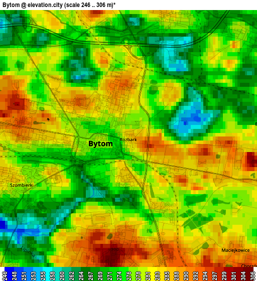
Below is the Elevation map of Bytom, which displays elevation range with different colors. Scale of the first map is from 246 to 306 m (807 to 1004 ft) with average elevation of 277.7 meters (=911 ft) [note 1]
These maps also provides idea of topography and contour of this city, they are displayed at different zoom levels. More info about maps, scale and edge coordinates you can find below images.
| \ | Map #1 | Map #2 | Topo.Map |
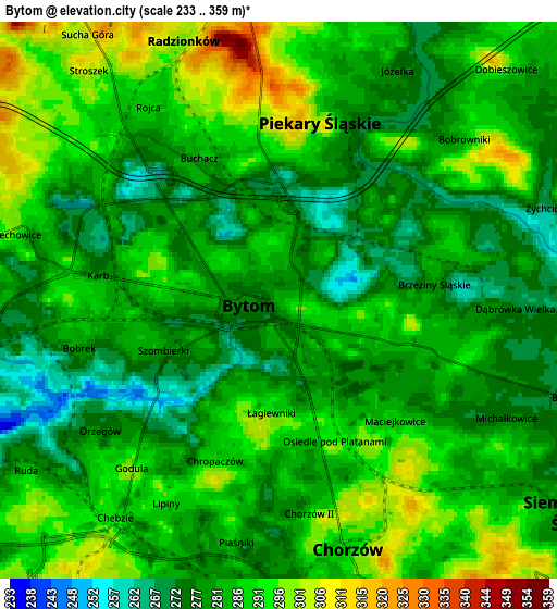
| Scale [m] | 246..306 m | 233..359 m | × |
| Scale [ft] | 807..1004 ft | 764..1178 ft | × |
| Average | 277.7 m = 911 ft | 284.5 m = 933 ft | × |
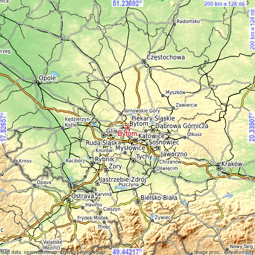
| Width | 6.24 km = 3.9 mi | 12.47 km = 7.7 mi | 199.6 km = 124 mi |
| Height | 6.24 km = 3.9 mi | 12.47 km = 7.7 mi | 199.5 km = 124 mi |
| ↑Max Latitude | 50.376054° | 50.404072° | 51.23692° |
| Latitude at center | 50.34802° | 50.34802° | 50.34802° |
| ↓Min Latitude | 50.319969° | 50.291902° | 49.44217° |
| ← Min Longitude | 18.888875° | 18.844929° | 17.52657° |
| Longitude center | 18.93282° | 18.93282° | 18.93282° |
| →Max Longitude | 18.976765° | 19.020711° | 20.33907° |
Nearby cities:
Cities around Bytom sort by population:
• Chorzów elevation 319 m
5.5 km,  147°
147°
• Siemianowice Śląskie 270 m
7.2 km,  108°
108°
• Piekary Śląskie 290 m
3.6 km,  352°
352°
• Świętochłowice 282 m
5.8 km,  190°
190°
• Radzionków 298 m
6.2 km,  339°
339°
• Wojkowice 289 m
7.6 km,  75°
75°
• Brzeziny Śląskie 285 m
3.5 km, 78°
• Nakło 313 m
10 km, 350°
• Bobrowniki 279 m
5.2 km,  47°
47°
• Rogoźnik 301 m
8.8 km,  57°
57°
• Orzech 299 m
8.9 km,  355°
355°
• Dobieszowice 282 m
7.9 km, 46°
Multilingual:
 En español:
Bytom elevación 285 m.
 En France:
Bytom élévation 285 m.


Sources and notes:
- [note 1] Map square and city borders are not equal. Map elevation data is calculated only from area inside that square.
- [src 1] Elevation data from geonames database provided with same terms of usage.
- [src 2] The elevation map of Bytom is generated using elevation data from NASA's 3 arcsec (90m) resolution SRTM data.
- [src 3] Base (background) map © OpenStreetMap contributors tiles are generated by Geofabrik and OpenTopoMap.
Copyright & License:
This Bytom Elevation Map is licensed under CC BY-SA. You may reuse any part from this page, if you give a proper credit by linking to this URL:
 More info on terms of use page.