Dunga Bunga elevation
Dunga Bunga (Punjab), Pakistan elevation is 161 meters and Dunga Bunga elevation in feet is 528 ft above sea level [src 1]. Dunga Bunga is a populated place (feature code) with elevation that is 185 meters (607 ft) smaller than average city elevation in Pakistan.
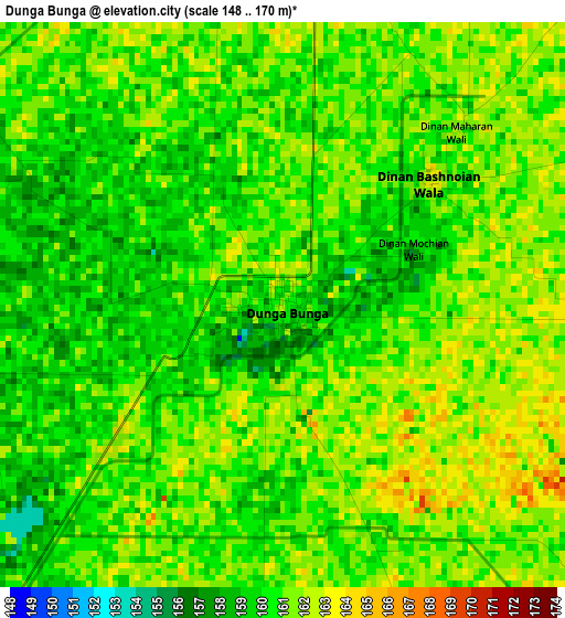
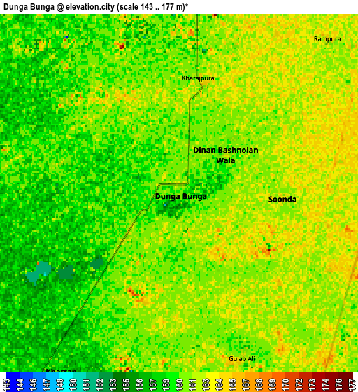
Below is the Elevation map of Dunga Bunga, which displays elevation range with different colors. Scale of the first map is from 148 to 170 m (486 to 558 ft) with average elevation of 160.4 meters (=526 ft) [note 1]
These maps also provides idea of topography and contour of this city, they are displayed at different zoom levels. More info about maps, scale and edge coordinates you can find below images.
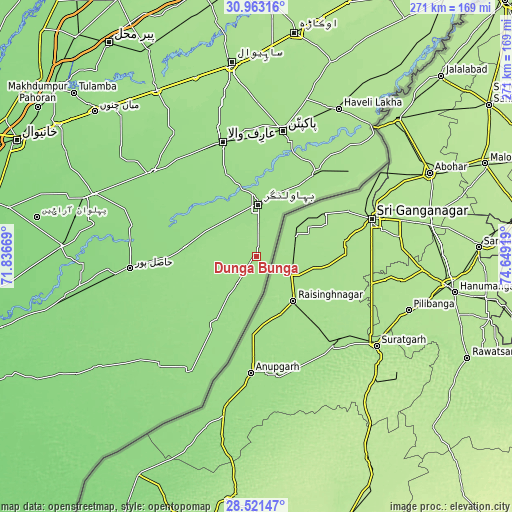
| \ | Map #1 | Map #2 | Topo.Map |
| Scale [m] | 148..170 m | 143..177 m | × |
| Scale [ft] | 486..558 ft | 469..581 ft | × |
| Average | 160.4 m = 526 ft | 160.5 m = 527 ft | × |
| Width | 8.48 km = 5.3 mi | 16.97 km = 10.5 mi | 271.5 km = 168.7 mi |
| Height | 8.48 km = 5.3 mi | 16.97 km = 10.5 mi | 271.5 km = 168.7 mi |
| ↑Max Latitude | 29.787896° | 29.826028° | 30.96316° |
| Latitude at center | 29.74975° | 29.74975° | 29.74975° |
| ↓Min Latitude | 29.711589° | 29.673414° | 28.52147° |
| ← Min Longitude | 73.198995° | 73.155049° | 71.83669° |
| Longitude center | 73.24294° | 73.24294° | 73.24294° |
| →Max Longitude | 73.286885° | 73.330831° | 74.64919° |
Nearby cities:
Cities around Dunga Bunga sort by population:
• Būrewāla elevation 146 m
73.6 km,  309°
309°
• Pakpattan 188 m
67.5 km,  12°
12°
• Bahawalnagar 159 m
27.7 km,  1°
1°
• Chishtian 149 m
37.5 km,  278°
278°
• Hasilpur 141 m
67.6 km,  264°
264°
• Arifwala 159 m
62.5 km,  344°
344°
• Harunabad 162 m
18.4 km,  213°
213°
• Fort Abbas 147 m
72.4 km, 211°
• Minchianabad 168 m
55.7 km,  34°
34°
• Faqirwali 155 m
37.2 km, 212°
• Chak One Hundred Twenty Nine Left 162 m
77.9 km,  345°
345°
• Dinan Bashnoian Wala 162 m
2.8 km,  50°
50°
Multilingual:
 En español:
Dunga Bunga elevación 161 m.
 En France:
Dunga Bunga élévation 161 m.
 Auf Deutsch:
Dunga Bunga höhe über dem Meeresspiegel ist 161 m.

Sources and notes:
- [note 1] Map square and city borders are not equal. Map elevation data is calculated only from area inside that square.
- [src 1] Elevation data from geonames database provided with same terms of usage.
- [src 2] The elevation map of Dunga Bunga is generated using elevation data from NASA's 3 arcsec (90m) resolution SRTM data.
- [src 3] Base (background) map © OpenStreetMap contributors tiles are generated by Geofabrik and OpenTopoMap.
Copyright & License:
This Dunga Bunga Elevation Map is licensed under CC BY-SA. You may reuse any part from this page, if you give a proper credit by linking to this URL:
 More info on terms of use page.